
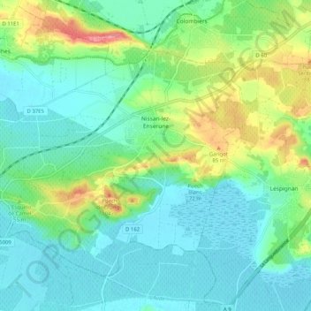
Nissan-lez-Enserune topographic map
Interactive map
Click on the map to display elevation.
About this map
Name: Nissan-lez-Enserune topographic map, elevation, terrain.
Average elevation: 32 m
Minimum elevation: 0 m
Maximum elevation: 121 m
Viticulture strongly marked the territory. From Roman times (where it is believed the name of the village originates), the vines spread both on the plain and the hillsides. However, the massive development of this monoculture dates from the end of the 19th century, previous maps and topography attest to the extension of other crops, in particular cereals in the plains areas in older periods (borne out by the three 17th-century windmills that mark the hilltops to the south of village). The old houses in the center of the village, as in all Languedoc villages, often have their own cellars and sheds that once housed wooden casks and horses so much so there is even a street named Avenue de la Cave, but the last wine producer from this street sold up a few years ago.