
June Lake topographic map
Interactive map
Click on the map to display elevation.
About this map
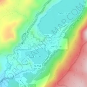
Name: June Lake topographic map, elevation, terrain.
Location: June Lake, Mono County, California, 93529, United States (37.77480 -119.08879 37.78380 -119.07132)
Average elevation: 2,445 m
Minimum elevation: 2,284 m
Maximum elevation: 2,764 m
June Lake is a census-designated place in Mono County, California. It is located against the southern rim of the Mono Basin, 12.5 miles (20 km) south of Lee Vining, at an elevation of 7654 feet (2333 m).