
el Vendrell topographic map
Interactive map
Click on the map to display elevation.
About this map
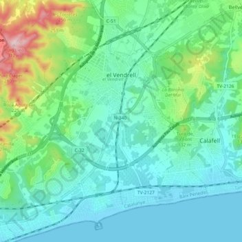
Name: el Vendrell topographic map, elevation, terrain.
Location: el Vendrell, Baix Penedès, Tarragona, Catalonia, 43700, Spain (41.17312 1.47678 41.24057 1.56734)
Average elevation: 67 m
Minimum elevation: -1 m
Maximum elevation: 308 m
Other topographic maps
Click on a map to view its topography, its elevation and its terrain.
Sant Jaume dels Domenys
Spain > Catalonia > Baix Penedès
Sant Jaume dels Domenys, Baix Penedès, Tarragona, Catalonia, 43713, Spain
Average elevation: 273 m
Bonastre
Spain > Catalonia > Baix Penedès
Bonastre, Baix Penedès, Tarragona, Catalonia, 43884, Spain
Average elevation: 234 m