
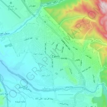
Yasuj topographic map
Interactive map
Click on the map to display elevation.
About this map
Name: Yasuj topographic map, elevation, terrain.
Average elevation: 1,860 m
Minimum elevation: 1,727 m
Maximum elevation: 2,375 m
Other topographic maps
Click on a map to view its topography, its elevation and its terrain.
Boyer Ahmad
Iran > Kohgiluye and Buyer Ahmad Province > Buyerahmad County > Yasuj
Boyer Ahmad, ناحیه ۱, Yasuj, بخش مرکزی بویراحمد, Buyerahmad County, Kohgiluye and Buyer Ahmad Province, Iran
Average elevation: 1,845 m
Abadeh
Iran > Kohgiluye and Buyer Ahmad Province > Buyerahmad County > دهستان لوداب
Abadeh, دهستان لوداب, بخش لوداب, Buyerahmad County, Kohgiluye and Buyer Ahmad Province, Iran
Average elevation: 1,548 m
Yasuj
Iran > Kohgiluye and Buyer Ahmad Province > Buyerahmad County > Yasuj
Yasuj, بخش مرکزی شهرستان بویراحمد, Buyerahmad County, Kohgiluye and Buyer Ahmad Province, 7591778449, Iran
Average elevation: 2,335 m