
Lublin topographic map
Interactive map
Click on the map to display elevation.
About this map
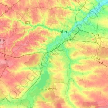
Name: Lublin topographic map, elevation, terrain.
Location: Lublin, Lublin Voivodeship, Poland (51.13981 22.45379 51.29656 22.67354)
Average elevation: 203 m
Minimum elevation: 160 m
Maximum elevation: 243 m
Other topographic maps
Click on a map to view its topography, its elevation and its terrain.
Głusk
Poland > Lublin Voivodeship > Lublin
Głusk, Lublin, Lublin Voivodeship, Poland
Average elevation: 194 m