
Passau topographic map
Interactive map
Click on the map to display elevation.
About this map
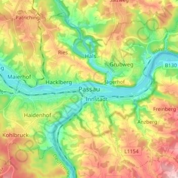
Name: Passau topographic map, elevation, terrain.
Location: Passau, Bavaria, 94032, Germany (48.53482 13.42097 48.61482 13.50097)
Average elevation: 380 m
Minimum elevation: 287 m
Maximum elevation: 507 m
On 2 June 2013, the old town suffered from severe flooding as a result of several days of rain and its location at the confluence of three rivers Peak elevations of floods as early as 1501 are displayed on a wall at the Old City Hall. Flood water reaches the base of that wall on average once every 5 years.:19