
Orangeville topographic map
Interactive map
Click on the map to display elevation.
About this map
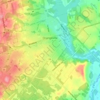
Name: Orangeville topographic map, elevation, terrain.
Average elevation: 444 m
Minimum elevation: 399 m
Maximum elevation: 500 m
Other topographic maps
Click on a map to view its topography, its elevation and its terrain.
Mono Centre
Canada > Ontario > Dufferin County > Mono
Mono Centre, Mono, Dufferin County, Central Ontario, Ontario, L9W 5Y2, Canada
Average elevation: 453 m
Mono
Canada > Ontario > Dufferin County
Mono, Dufferin County, Central Ontario, Ontario, Canada
Average elevation: 440 m