
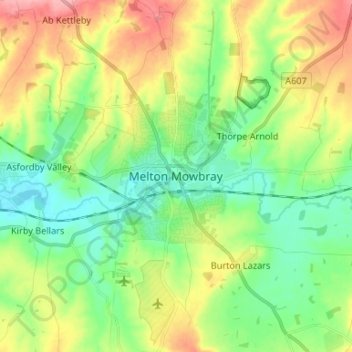
Melton Mowbray topographic map
Interactive map
Click on the map to display elevation.
About this map
Name: Melton Mowbray topographic map, elevation, terrain.
Average elevation: 103 m
Minimum elevation: 65 m
Maximum elevation: 167 m
Other topographic maps
Click on a map to view its topography, its elevation and its terrain.
Brooksby
United Kingdom > England > Leicestershire > Melton > Rotherby
Brooksby, Hoby with Rotherby, Rotherby, Melton, Leicestershire, England, LE14 2LE, United Kingdom
Average elevation: 76 m
Ab Kettleby
United Kingdom > England > Leicestershire > Melton
Ab Kettleby, Melton, Leicestershire, England, United Kingdom
Average elevation: 126 m
Pickwell
United Kingdom > England > Leicestershire > Melton
Pickwell, Melton, Leicestershire, England, LE14 2PL, United Kingdom
Average elevation: 168 m
Belvoir Castle
United Kingdom > England > Leicestershire > Melton > Belvoir
Belvoir Castle, Woolsthorpe Road, Belvoir, Melton, Leicestershire, England, NG32 1PH, United Kingdom
Average elevation: 82 m
Great Dalby
United Kingdom > England > Leicestershire > Melton
Great Dalby, Melton, Leicestershire, England, LE14 2EN, United Kingdom
Average elevation: 121 m
Saltby
United Kingdom > England > Leicestershire > Melton
Saltby, Melton, Leicestershire, England, LE14 4QW, United Kingdom
Average elevation: 144 m
Bottesford
United Kingdom > England > Leicestershire > Melton
Bottesford, Melton, Leicestershire, England, United Kingdom
Average elevation: 39 m
Harby
United Kingdom > England > Leicestershire > Melton > Harby
Harby, Melton, Leicestershire, East Midlands, England, United Kingdom
Average elevation: 51 m
Hose
United Kingdom > England > Leicestershire > Melton
Hose, Melton, Leicestershire, England, LE14 4JP, United Kingdom
Average elevation: 58 m
Goadby Marwood
United Kingdom > England > Leicestershire > Melton
Goadby Marwood, Melton, Leicestershire, England, LE14 4LL, United Kingdom
Average elevation: 140 m
Asfordby
United Kingdom > England > Leicestershire > Melton
Asfordby, Melton, Leicestershire, England, LE14 3TT, United Kingdom
Average elevation: 88 m
Beacon Hill
United Kingdom > England > Leicestershire > Melton
Beacon Hill, Melton, Leicestershire, England, NG13 0EZ, United Kingdom
Average elevation: 36 m
Stathern
United Kingdom > England > Leicestershire > Melton
Stathern, Melton, Leicestershire, England, LE14 4HP, United Kingdom
Average elevation: 90 m
Hoby
United Kingdom > England > Leicestershire > Melton
Hoby, Melton, Leicestershire, England, LE14 3DU, United Kingdom
Average elevation: 78 m
Sewstern
United Kingdom > England > Leicestershire > Melton
Sewstern, Melton, Leicestershire, England, NG33 5RQ, United Kingdom
Average elevation: 136 m
Burton Lazars
United Kingdom > England > Leicestershire > Melton
Burton Lazars, Melton, Leicestershire, England, LE14 2UB, United Kingdom
Average elevation: 96 m
Saxelbye
United Kingdom > England > Leicestershire > Melton
Saxelbye, Melton, Leicestershire, England, LE14 3PQ, United Kingdom
Average elevation: 111 m