
Lisburn topographic map
Interactive map
Click on the map to display elevation.
About this map
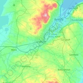
Name: Lisburn topographic map, elevation, terrain.
Average elevation: 92 m
Minimum elevation: -2 m
Maximum elevation: 471 m
Other topographic maps
Click on a map to view its topography, its elevation and its terrain.
Belfast
United Kingdom > Northern Ireland > County Antrim
Belfast, County Antrim, Northern Ireland, BT1 5GS, United Kingdom
Average elevation: 87 m
Portballintrae
United Kingdom > Northern Ireland > County Antrim
Portballintrae, County Antrim, Northern Ireland, BT57 8RZ, United Kingdom
Average elevation: 27 m
Portglenone
United Kingdom > Northern Ireland > County Antrim
Portglenone, County Antrim, Northern Ireland, BT44 8AD, United Kingdom
Average elevation: 43 m
Martinstown
United Kingdom > Northern Ireland > County Antrim
Martinstown, County Antrim, Northern Ireland, BT43 6QH, United Kingdom
Average elevation: 174 m
Tildarg
United Kingdom > Northern Ireland > County Antrim
Tildarg, County Antrim, Northern Ireland, BT39 9ZW, United Kingdom
Average elevation: 204 m
Nutts Corner
United Kingdom > Northern Ireland > County Antrim
Nutts Corner, County Antrim, Northern Ireland, BT29 4SR, United Kingdom
Average elevation: 105 m
Ballygomartin
United Kingdom > Northern Ireland > County Antrim > Belfast
Ballygomartin, Ligoniel, Belfast, County Antrim, Northern Ireland, United Kingdom
Average elevation: 258 m
Aghagallon
United Kingdom > Northern Ireland > County Antrim
Aghagallon, County Antrim, Northern Ireland, BT67 0AR, United Kingdom
Average elevation: 31 m
Ballymena
United Kingdom > Northern Ireland > County Antrim
Ballymena, County Antrim, Northern Ireland, BT43 6DT, United Kingdom
Average elevation: 74 m
Whitehead
United Kingdom > Northern Ireland > County Antrim
Whitehead, County Antrim, Northern Ireland, BT38 9RU, United Kingdom
Average elevation: 37 m
Botanic Gardens
United Kingdom > Northern Ireland > County Antrim > Belfast
Botanic Gardens, Queen's Quarter, Belfast, County Antrim, Northern Ireland, United Kingdom
Average elevation: 15 m
Carrickfergus
United Kingdom > Northern Ireland > County Antrim
Carrickfergus, County Antrim, Northern Ireland, BT38 7AN, United Kingdom
Average elevation: 49 m
Lough Neagh
United Kingdom > Northern Ireland > County Antrim
Lough Neagh, County Antrim, Ulster, Northern Ireland, United Kingdom
Average elevation: 29 m
Upper Ballinderry
United Kingdom > Northern Ireland > County Antrim
Upper Ballinderry, County Antrim, Ulster, Northern Ireland, BT28 2LW, United Kingdom
Average elevation: 74 m
Ballyclare
United Kingdom > Northern Ireland > County Antrim
Ballyclare, County Antrim, Northern Ireland, BT39 9BB, United Kingdom
Average elevation: 120 m
Lisnacrogher
United Kingdom > Northern Ireland > County Antrim
Lisnacrogher, County Antrim, Ulster, Northern Ireland, United Kingdom
Average elevation: 108 m
Ballymoney
United Kingdom > Northern Ireland > County Antrim
Ballymoney, County Antrim, Northern Ireland, BT53 6AY, United Kingdom
Average elevation: 51 m
Old Mill
United Kingdom > Northern Ireland > County Antrim > Ballygally
Old Mill, Ballygally, County Antrim, Ulster, Northern Ireland, BT40 2RX, United Kingdom
Average elevation: 47 m
Straid
United Kingdom > Northern Ireland > County Antrim
Straid, County Antrim, Ulster, Northern Ireland, BT39 9NQ, United Kingdom
Average elevation: 177 m
Ballintoy
United Kingdom > Northern Ireland > County Antrim
Ballintoy, County Antrim, Ulster, Northern Ireland, BT54 6LX, United Kingdom
Average elevation: 73 m
Maghaberry
United Kingdom > Northern Ireland > County Antrim
Maghaberry, County Antrim, Ulster, Northern Ireland, BT67 0JE, United Kingdom
Average elevation: 65 m
Ballycastle
United Kingdom > Northern Ireland > County Antrim
Ballycastle, County Antrim, Northern Ireland, BT54 6AW, United Kingdom
Average elevation: 79 m
Cullybackey
United Kingdom > Northern Ireland > County Antrim
Cullybackey, County Antrim, Ulster, Northern Ireland, BT42 1NH, United Kingdom
Average elevation: 92 m
Larne
United Kingdom > Northern Ireland > County Antrim
Larne, County Antrim, Northern Ireland, BT40 1JS, United Kingdom
Average elevation: 54 m
Armoy
United Kingdom > Northern Ireland > County Antrim
Armoy, County Antrim, Ulster, Northern Ireland, BT53 8RH, United Kingdom
Average elevation: 102 m
Dunadry
United Kingdom > Northern Ireland > County Antrim
Dunadry, County Antrim, Ulster, Northern Ireland, BT41 4QT, United Kingdom
Average elevation: 66 m
Cavehill
United Kingdom > Northern Ireland > County Antrim > Belfast
Cavehill, Belfast, County Antrim, Northern Ireland, BT36 7PN, United Kingdom
Average elevation: 188 m
Portrush
United Kingdom > Northern Ireland > County Antrim
Portrush, County Antrim, Northern Ireland, BT56 8BN, United Kingdom
Average elevation: 23 m
Kinbane Castle
United Kingdom > Northern Ireland > County Antrim > Ballycastle
Kinbane Castle, Whitepark Road, Ballycastle, County Antrim, Northern Ireland, BT54 6GA, United Kingdom
Average elevation: 37 m
Dunloy
United Kingdom > Northern Ireland > County Antrim
Dunloy, County Antrim, Northern Ireland, BT44 9EF, United Kingdom
Average elevation: 128 m
Cargan
United Kingdom > Northern Ireland > County Antrim > Cargan
Cargan, County Antrim, Ulster, Northern Ireland, BT43 6RB, United Kingdom
Average elevation: 246 m
Kells
United Kingdom > Northern Ireland > County Antrim
Kells, County Antrim, Ulster, Northern Ireland, BT42 3LS, United Kingdom
Average elevation: 90 m
McArt's Fort
United Kingdom > Northern Ireland > County Antrim > Belfast
McArt's Fort, Ben Madigan Heights, Whitewell, Belfast, County Antrim, Northern Ireland, BT36 7RW, United Kingdom
Average elevation: 165 m
Randalstown
United Kingdom > Northern Ireland > County Antrim
Randalstown, County Antrim, Northern Ireland, BT41 3AD, United Kingdom
Average elevation: 57 m
Glengormley
United Kingdom > Northern Ireland > County Antrim > Newtownabbey
Glengormley, Newtownabbey, County Antrim, Northern Ireland, United Kingdom
Average elevation: 154 m
Islandmagee
United Kingdom > Northern Ireland > County Antrim
Islandmagee, County Antrim, Northern Ireland, BT40 3SH, United Kingdom
Average elevation: 23 m
Magheragall
United Kingdom > Northern Ireland > County Antrim > Lisburn
Magheragall, Lisburn, County Antrim, Northern Ireland, BT28 2XF, United Kingdom
Average elevation: 52 m
Antrim
United Kingdom > Northern Ireland > County Antrim
Antrim, County Antrim, Northern Ireland, BT41 4AR, United Kingdom
Average elevation: 50 m
Kilwaughter
United Kingdom > Northern Ireland > County Antrim > Kilwaughter
Kilwaughter, County Antrim, Northern Ireland, BT40 2PT, United Kingdom
Average elevation: 161 m
Dunmurry
United Kingdom > Northern Ireland > County Antrim > Lisburn
Dunmurry, Lisburn, County Antrim, Ulster, Northern Ireland, United Kingdom
Average elevation: 38 m
Rasharkin
United Kingdom > Northern Ireland > County Antrim
Rasharkin, County Antrim, Northern Ireland, BT44 8RX, United Kingdom
Average elevation: 89 m
Dervock
United Kingdom > Northern Ireland > County Antrim > Dervock
Dervock, County Antrim, Northern Ireland, BT53 8BT, United Kingdom
Average elevation: 44 m
Tamybuck
United Kingdom > Northern Ireland > County Antrim > Aughafatten
Tamybuck, Aughafatten, County Antrim, Northern Ireland, BT42 4LP, United Kingdom
Average elevation: 171 m
Cushendun
United Kingdom > Northern Ireland > County Antrim
Cushendun, County Antrim, Ulster, Northern Ireland, BT44 0PH, United Kingdom
Average elevation: 59 m
Edenderry
United Kingdom > Northern Ireland > County Antrim > Belfast
Edenderry, Woodvale, Belfast, County Antrim, Northern Ireland, United Kingdom
Average elevation: 50 m
Bushmills
United Kingdom > Northern Ireland > County Antrim
Bushmills, County Antrim, Northern Ireland, BT57 8QB, United Kingdom
Average elevation: 42 m
Carnlough
United Kingdom > Northern Ireland > County Antrim
Carnlough, County Antrim, Ulster, Northern Ireland, BT44 0EU, United Kingdom
Average elevation: 77 m
Ahoghill
United Kingdom > Northern Ireland > County Antrim
Ahoghill, County Antrim, Northern Ireland, BT42 1JZ, United Kingdom
Average elevation: 84 m
Newtownabbey
United Kingdom > Northern Ireland > County Antrim
Newtownabbey, County Antrim, Northern Ireland, BT36 6UN, United Kingdom
Average elevation: 100 m
Glenavy
United Kingdom > Northern Ireland > County Antrim
Glenavy, County Antrim, Northern Ireland, BT29 4PP, United Kingdom
Average elevation: 76 m