
Biel/Bienne topographic map
Interactive map
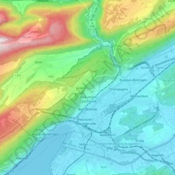
Click on the map to display elevation.
About this map
Name: Biel/Bienne topographic map, elevation, terrain.
Average elevation: 655 m
Minimum elevation: 423 m
Maximum elevation: 1,282 m
One funicular railways leads to the national sports center of Magglingen/Macolin on the 500 metres (1,600 ft) higher Jura mountain in the west, and the other, the Bienne-Evilard Funicular, to the city hospital and to neighbouring municipality Evilard to northwest, both above the town on the eastern range of the Jura Mountains. The high, flat pastures and wood of Magglingen/Macolin span about 7 kilometres (4.3 mi) from northeast to southwest at an altitude between 800 and 1,031 metres (2,625 and 3,383 ft). The Magglingen/Macolin Funicular often leads to sunshine while Biel/Bienne is covered by low hanging clouds.
Other topographic maps
Click on a map to view its topography, its elevation and its terrain.
Meinisberg
Switzerland > Bern > Biel/Bienne administrative district
Meinisberg, Biel/Bienne administrative district, Seeland administrative region, Bern, 2554, Switzerland
Average elevation: 455 m