
Gentilly topographic map
Interactive map
Click on the map to display elevation.
About this map
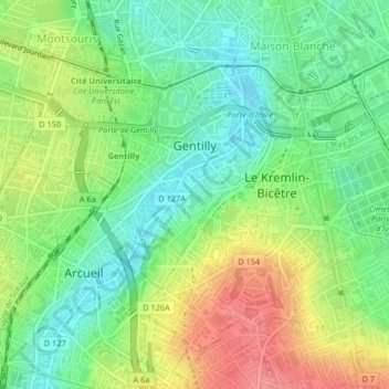
Name: Gentilly topographic map, elevation, terrain.
Average elevation: 72 m
Minimum elevation: 40 m
Maximum elevation: 118 m
Other topographic maps
Click on a map to view its topography, its elevation and its terrain.
Saint-Maur-des-Fossés
France > Val-de-Marne > Saint-Maur-des-Fossés > Saint-Maur-des-Fossés
Average elevation: 54 m