
Vinhais topographic map
Interactive map
Click on the map to display elevation.
About this map
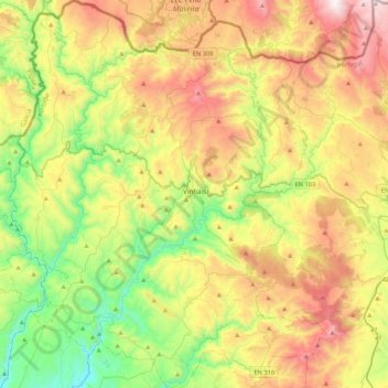
Name: Vinhais topographic map, elevation, terrain.
Location: Vinhais, Bragança, Portugal (41.67113 -7.21360 41.99076 -6.86096)
Average elevation: 779 m
Minimum elevation: 258 m
Maximum elevation: 1,527 m
It is perched on the slopes of the Coroa mountains at an altitude of approximately 600 meters, protected from the cold winds of the north by the Ciradelha mountain, where in remote times there was a Luso-Roman castro. On the south side is the Tuela River valley. There are three other rivers in the concelho: the Rabaçal, the Mente, and the Baceiro. They are relatively unpolluted and provide fish for locals and tourists. The Baceiro has a trout hatchery which is deactivated but will be reopened soon.
Other topographic maps
Click on a map to view its topography, its elevation and its terrain.
Penhas Juntas
Penhas Juntas, Vinhais, Bragança, Portugal
Average elevation: 715 m
Montesinho Nature Park
Portugal > Bragança > Bragança > Espinhosela
Montesinho Nature Park, Espinhosela, Bragança, 5300-245, Portugal
Average elevation: 881 m
Carrazeda de Ansiães
Carrazeda de Ansiães, Bragança, Portugal
Average elevation: 538 m
Macedo de Cavaleiros
Portugal > Bragança > Macedo de Cavaleiros
Macedo de Cavaleiros, Bragança, Portugal
Average elevation: 594 m
Mua
Portugal > Bragança > Torre de Moncorvo
Mua, Torre de Moncorvo, Bragança, Portugal
Average elevation: 695 m