
Istanbul topographic map
Interactive map
Click on the map to display elevation.
About this map
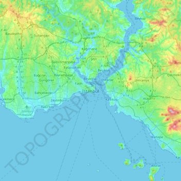
Name: Istanbul topographic map, elevation, terrain.
Location: Istanbul, Fatih, Istanbul, Marmara Region, 34122, Turkey (40.84638 28.81587 41.16638 29.13587)
Average elevation: 57 m
Minimum elevation: -2 m
Maximum elevation: 429 m
Because of its hilly topography and maritime influences, Istanbul exhibits a multitude of distinct microclimates. Within the city, rainfall varies widely owing to the rain shadow of the hills in Istanbul, from around 600 millimeters (24 in) on the southern fringe at Florya to 1,200 millimeters (47 in) on the northern fringe at Bahçeköy.
Other topographic maps
Click on a map to view its topography, its elevation and its terrain.
Zeyrek Mahallesi
Zeyrek Mahallesi, Fatih, Istanbul, Marmara Region, Turkey
Average elevation: 34 m
Kalenderhane Mahallesi
Kalenderhane Mahallesi, Fatih, Istanbul, Marmara Region, 34120, Turkey
Average elevation: 28 m
Balat Mahallesi
Balat Mahallesi, Fatih, Istanbul, Marmara Region, Turkey
Average elevation: 34 m
Cibali Mahallesi
Cibali Mahallesi, Fatih, Istanbul, Marmara Region, Turkey
Average elevation: 30 m
Sururi Mahallesi
Sururi Mahallesi, Fatih, Istanbul, Marmara Region, Turkey
Average elevation: 19 m