
Kerala topographic map
Interactive map
Click on the map to display elevation.
About this map
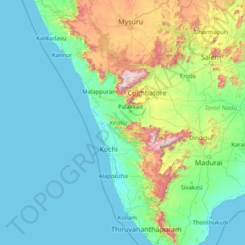
Name: Kerala topographic map, elevation, terrain.
Location: Kerala, India (8.29353 74.86407 12.79606 77.41236)
Average elevation: 251 m
Minimum elevation: -4 m
Maximum elevation: 2,557 m
Kerala was alternatively called Malabar in the foreign trade circles. Earlier, the term Malabar had also been used to denote Tulu Nadu and Kanyakumari which lie contiguous to Kerala on the southwestern coast of India, in addition to the modern state of Kerala. The people of Malabar were known as Malabars. Until the arrival of the East India Company, the term Malabar was used as a general name for Kerala, along with the term Kerala. From the time of Cosmas Indicopleustes (6th century CE) itself, the Arab sailors used to call Kerala as Male. The first element of the name, however, is attested already in the Topography written by Cosmas Indicopleustes. This mentions a pepper emporium called Male, which clearly gave its name to Malabar ('the country of Male'). The name Male is thought to come from the Malayalam word Mala ('hill'). Al-Biruni (973–1048 CE) is the first known writer to call this country Malabar. Authors such as Ibn Khordadbeh and Al-Baladhuri mention Malabar ports in their works. The Arab writers had called this place Malibar, Manibar, Mulibar, and Munibar. Malabar is reminiscent of the word Malanad which means the land of hills. According to William Logan, the word Malabar comes from a combination of the Malayalam word Mala (hill) and the Persian/Arabic word Barr (country/continent).
Other topographic maps
Click on a map to view its topography, its elevation and its terrain.
Bengaluru
India > Karnataka > Bangalore North
Bengaluru, Bangalore North, Bengaluru Urban District, Karnataka, India
Average elevation: 881 m
Chennai
India > Tamil Nadu > Chennai
Chennai, Chennai District, Tamil Nadu, India
Average elevation: 8 m
Pune
India > Maharashtra > Pune City > Pune
Pune, Pune City, Pune District, Maharashtra, 411001, India
Average elevation: 641 m
3d
India > Rajasthan > Ganganagar Tehsil > 1 LNP
3d, 1 LNP, Ganganagar Tehsil, Sri Ganganagar District, Rajasthan, India
Average elevation: 178 m
Panhala Fort
India > Maharashtra > Shahuwadi > Panhala
Panhala Fort, NH166, Panhala, Shahuwadi, Kolhapur, Maharashtra, 416201, India
Average elevation: 825 m
Kolkata
Kolkata, Kolkata District, West Bengal, 700073, India
Average elevation: 5 m
Jaipur
India > Rajasthan > Jaipur Tehsil
Jaipur, Jaipur Municipal Corporation, Jaipur Tehsil, Jaipur District, Rajasthan, 302001, India
Average elevation: 408 m
Tamnath
India > Maharashtra > Karjat
Tamnath, Karjat, Raigad, Maharashtra, 410201, India
Average elevation: 110 m
Kadaganchi
India > Karnataka > Alanda taluku
Kadaganchi, Alanda taluku, Kalaburagi District, Karnataka, 585311, India
Average elevation: 528 m
Tharangambadi
Tharangambadi, Mayiladuthurai District, Tamil Nadu, India
Average elevation: 5 m
Nuapatana
India > Odisha > Narasinghpur
Nuapatana, Narasinghpur, Cuttack District, Odisha, 754032, India
Average elevation: 63 m
Bhubaneshwar
India > Odisha > Bhubaneswar (M.Corp.)
Bhubaneshwar, Bhubaneswar Municipal Corporation, Bhubaneswar (M.Corp.), Khordha District, Odisha, 751001, India
Average elevation: 30 m
Bhubaneswar Municipal Corporation
India > Odisha > Bhubaneswar (M.Corp.)
Bhubaneswar Municipal Corporation, Bhubaneswar (M.Corp.), Khordha, Odisha, India
Average elevation: 37 m
Jodhpur
India > Rajasthan > Jodhpur Tehsil
Jodhpur, Jodhpur Tehsil, Jodhpur District, Rajasthan, India
Average elevation: 238 m
Shimla
India > Himachal Pradesh > Shimla (urban)
Shimla, Shimla (urban), Shimla District, Himachal Pradesh, 171001, India
Average elevation: 1,557 m
Srinagar
India > Jammu and Kashmir > Srinagar (South)
Srinagar, Srinagar (South), Srinagar District, Jammu and Kashmir, 190001, India
Average elevation: 1,805 m
Indore
India > Madhya Pradesh > Juni Indore Tahsil
Indore, Juni Indore Tahsil, Indore District, Madhya Pradesh, 452001, India
Average elevation: 555 m
Patna
India > Bihar > Patna Rural
Patna, Patna Rural, Patna District, Bihar, 800001, India
Average elevation: 51 m
Kanakapura
India > Karnataka > Kanakapura taluk
Kanakapura, Kanakapura taluk, Ramanagara District, Karnataka, 562117, India
Average elevation: 663 m
Kaas Valley of Flowers
India > Maharashtra > Jaoli > Daund
Kaas Valley of Flowers, Daund, Jaoli, Satara, Maharashtra, India
Average elevation: 1,011 m
Gudibande
India > Karnataka > Gudibande taluk
Gudibande, Gudibande taluk, Chikkaballapura District, Karnataka, 561209, India
Average elevation: 833 m
Chhindwara
India > Madhya Pradesh > Chhindwara Tahsil
Chhindwara, Chhindwara Tahsil, Chhindwara District, Madhya Pradesh, 480001, India
Average elevation: 683 m
Thirukodikaval
India > Tamil Nadu > Thiruvidaimarudur
Thirukodikaval, Thiruvidaimarudur, Thanjavur District, Tamil Nadu, 609803, India
Average elevation: 18 m
Hosur
India > Tamil Nadu > Hosur
Hosur, Krishnagiri District, Tamil Nadu, 635109, India
Average elevation: 859 m
Gurgaon
India > Haryana > Gurugram District
Gurgaon, Gurugram District, Haryana, India
Average elevation: 237 m