
Tamil Nadu topographic map
Interactive map
Click on the map to display elevation.
About this map
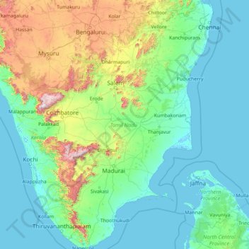
Name: Tamil Nadu topographic map, elevation, terrain.
Location: Tamil Nadu, India (8.07689 76.23295 13.56252 80.35930)
Average elevation: 253 m
Minimum elevation: -4 m
Maximum elevation: 2,557 m
The annual rainfall of the state is about 945 mm (37.2 in) of which 48 per cent is through the northeast monsoon, and 32 per cent through the southwest monsoon. Since the state is entirely dependent on rains for recharging its water resources, monsoon failures lead to acute water scarcity and severe drought. Tamil Nadu is divided into seven agro-climatic zones: northeast, northwest, west, southern, high rainfall, high altitude hilly, and Kaveri Delta (the most fertile agricultural zone).
Other topographic maps
Click on a map to view its topography, its elevation and its terrain.
Bengaluru
India > Karnataka > Bangalore North
Bengaluru, Bangalore North, Bengaluru Urban District, Karnataka, India
Average elevation: 881 m
Chennai
India > Tamil Nadu > Chennai
Chennai, Chennai District, Tamil Nadu, India
Average elevation: 8 m
3d
India > Rajasthan > Ganganagar Tehsil > 1 LNP
3d, 1 LNP, Ganganagar Tehsil, Sri Ganganagar District, Rajasthan, India
Average elevation: 178 m
Pune
India > Maharashtra > Pune City > Pune
Pune, Pune City, Pune District, Maharashtra, 411001, India
Average elevation: 641 m
Kolkata
Kolkata, Kolkata District, West Bengal, 700073, India
Average elevation: 5 m
Indore
India > Madhya Pradesh > Juni Indore Tahsil
Indore, Juni Indore Tahsil, Indore District, Madhya Pradesh, 452001, India
Average elevation: 555 m
Bengaluru
India > Karnataka > Bangalore North
Bengaluru, Bangalore North, Bengaluru Urban, Karnataka, 560001, India
Average elevation: 879 m
Bachupally mandal
Bachupally mandal, Medchal–Malkajgiri District, Telangana, 500090, India
Average elevation: 593 m
Gurgaon
India > Haryana > Gurugram District
Gurgaon, Gurugram District, Haryana, India
Average elevation: 237 m
Tamnath
India > Maharashtra > Karjat
Tamnath, Karjat, Raigad, Maharashtra, 410201, India
Average elevation: 110 m
Coimbatore
India > Tamil Nadu > Coimbatore North
Coimbatore, Coimbatore North, Coimbatore District, Tamil Nadu, 641001, India
Average elevation: 452 m
Kanakapura
India > Karnataka > Kanakapura taluk
Kanakapura, Kanakapura taluk, Ramanagara District, Karnataka, 562117, India
Average elevation: 663 m
Bodinayakanur
Bodinayakanur, Theni District, Tamil Nadu, India
Average elevation: 894 m
Jodhpur
India > Rajasthan > Jodhpur Tehsil
Jodhpur, Jodhpur Tehsil, Jodhpur District, Rajasthan, India
Average elevation: 238 m
Jaipur
India > Rajasthan > Jaipur Tehsil
Jaipur, Jaipur Municipal Corporation, Jaipur Tehsil, Jaipur District, Rajasthan, 302001, India
Average elevation: 408 m
Kuttapalayam
India > Tamil Nadu > Perundurai
Kuttapalayam, Perundurai, Erode District, Tamil Nadu, 638112, India
Average elevation: 254 m
Panhala Fort
India > Maharashtra > Shahuwadi > Panhala
Panhala Fort, NH166, Panhala, Shahuwadi, Kolhapur, Maharashtra, 416201, India
Average elevation: 825 m
Bhubaneshwar
India > Odisha > Bhubaneswar (M.Corp.)
Bhubaneshwar, Bhubaneswar Municipal Corporation, Bhubaneswar (M.Corp.), Khordha District, Odisha, 751001, India
Average elevation: 30 m
Mysuru
India > Karnataka > Mysuru taluk
Mysuru, Mysuru taluk, Mysuru District, Karnataka, 570001, India
Average elevation: 727 m
Thandal
India > Jammu and Kashmir > Udhampur
Thandal, Udhampur, Udhampur District, Jammu and Kashmir, India
Average elevation: 1,312 m
Paramathi
India > Tamil Nadu > Paramathi-Velur
Paramathi, Paramathi-Velur, Namakkal District, Tamil Nadu, 637207, India
Average elevation: 146 m
Irinjalakuda
India > Kerala > Mukundapuram
Irinjalakuda, Mukundapuram, Thrissur District, Kerala, 680100, India
Average elevation: 7 m
Hosur
India > Tamil Nadu > Hosur
Hosur, Krishnagiri District, Tamil Nadu, 635109, India
Average elevation: 859 m
Sankarankovil
India > Tamil Nadu > Sankarankoil
Sankarankovil, Sankarankoil, Tenkasi District, Tamil Nadu, 627756, India
Average elevation: 153 m
Sembatti
India > Tamil Nadu > Nilakkottai
Sembatti, Nilakkottai, Dindigul District, Tamil Nadu, 624707, India
Average elevation: 287 m
Kotturu
India > Andhra Pradesh > Kaviti
Kotturu, Kaviti, Srikakulam, Andhra Pradesh, 532322, India
Average elevation: 43 m
Holalkere
India > Karnataka > Holalkere taluk
Holalkere, Holalkere taluk, Chitradurga District, Karnataka, 577526, India
Average elevation: 715 m
Diya
India > Maharashtra > Dharni
Diya, Dharni, Amravati, Maharashtra, 444702, India
Average elevation: 323 m
Kaas Valley of Flowers
India > Maharashtra > Jaoli > Daund
Kaas Valley of Flowers, Daund, Jaoli, Satara, Maharashtra, India
Average elevation: 1,011 m