
North Brabant topographic map
Interactive map
Click on the map to display elevation.
About this map
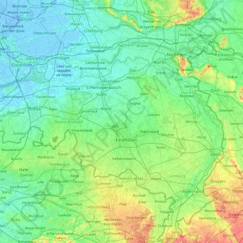
Name: North Brabant topographic map, elevation, terrain.
Location: North Brabant, Netherlands (51.22091 4.19012 51.83075 6.04812)
Average elevation: 22 m
Minimum elevation: -7 m
Maximum elevation: 158 m
The historical region of Kempen occupies the southern part of the province of Noord-Brabant and extends south of Eindhoven far into northern Belgium. To the east it reaches as far as the Meuse valley. The surface topography of De Kempen is very uniform. Most of it lies between 5m/15 ft and 35m/115 ft above sea level. The basement rocks are Cretaceous and Tertiary sediments, which are overlaid by Ice Age gravels and sands carried here by rivers of melt-water from the retreating glaciers. It is a typical area of sandy heathland. The infertile soil is suitable only for undemanding crops such as rye, oats, potatoes and fodder plants; this limits the profitability of agriculture. Until a few decades ago Kempen was a region of heathland and sand drifts with a sparse growth of pines, a few scattered villages subsisting on the poor soil and some small towns; and this is still the pattern in much of the region. In recent years, however, the rapid advance of industry has brought about profound changes in this agricultural region. The origins of this industrial development go back 70–100 years. The main concentrations of industry are along the southern frontier of the Netherlands, e.g., at Eindhoven, Helmond, Tilburg, Breda, 's-Hertogenbosch.
Other topographic maps
Click on a map to view its topography, its elevation and its terrain.
Zevenbergen
Zevenbergen, Moerdijk, North Brabant, Netherlands
Average elevation: 1 m
Noordwijkerhout
Netherlands > South Holland > Noordwijk
Noordwijkerhout, Noordwijk, South Holland, Netherlands
Average elevation: 2 m
Haarlem
Netherlands > North Holland > Haarlem
Haarlem, North Holland, Netherlands
Average elevation: 3 m
Helle
Netherlands > Limburg > Mechelen
Helle, Mechelen, Gulpen-Wittem, Limburg, Netherlands, 6281 BS, Netherlands
Average elevation: 158 m
Onstwedde
Onstwedde, Stadskanaal, Groningen, Netherlands
Average elevation: 4 m
Braassemermeer
Netherlands > South Holland > Rijnsaterwoude
Braassemermeer, Rijnsaterwoude, Kaag en Braassem, South Holland, Netherlands
Average elevation: -2 m
Ginderdoor
Netherlands > North Brabant > Chaam
Ginderdoor, Chaam, Alphen-Chaam, North Brabant, Netherlands, 4861 CG, Netherlands
Average elevation: 11 m
Kinderdijk
Kinderdijk, Molenlanden, South Holland, Netherlands
Average elevation: 1 m
Meijendel
Netherlands > South Holland > Wassenaar
Meijendel, Wassenaar, South Holland, Netherlands, 2244 AG, Netherlands
Average elevation: 6 m
Helvoirt
Helvoirt, Vught, North Brabant, Netherlands
Average elevation: 7 m
Heesakker
Netherlands > North Brabant > Haaren
Heesakker, Haaren, Oisterwijk, North Brabant, Netherlands, 5076 PR, Netherlands
Average elevation: 7 m
De Moer
De Moer, Loon op Zand, North Brabant, Netherlands
Average elevation: 7 m
Friese Buurt
Netherlands > North Holland > Den Helder
Friese Buurt, Den Helder, North Holland, Netherlands, 1786 PL, Netherlands
Average elevation: 0 m
Berlicum
Berlicum, Sint-Michielsgestel, North Brabant, Netherlands
Average elevation: 6 m
Oppenhuizen
Oppenhuizen, Súdwest-Fryslân, Frisia, Netherlands
Average elevation: 0 m
Westernieland
Westernieland, Het Hogeland, Groningen, Netherlands
Average elevation: 0 m
Valkeveen
Netherlands > North Holland > Naarden
Valkeveen, Naarden, Gooise Meren, North Holland, Netherlands, 1411 GT, Netherlands
Average elevation: 2 m
Wijk bij Duurstede
Netherlands > Utrecht > Wijk bij Duurstede
Wijk bij Duurstede, Utrecht, Netherlands
Average elevation: 5 m
Abbenes
Abbenes, Haarlemmermeer, North Holland, Netherlands
Average elevation: -4 m
Berenbroek
Netherlands > North Brabant > Helmond
Berenbroek, Helmond, North Brabant, Netherlands, 5707 DB, Netherlands
Average elevation: 19 m
Sint-Oedenrode
Sint-Oedenrode, Meierijstad, North Brabant, Netherlands
Average elevation: 12 m
Vierhuizen
Netherlands > Frisia > Allingawier
Vierhuizen, Allingawier, Súdwest-Fryslân, Frisia, Netherlands, 8758 LG, Netherlands
Average elevation: -2 m
Luchtpark Hofbogen
Netherlands > South Holland > Rotterdam
Luchtpark Hofbogen, Agniesebuurt, Noord, Rotterdam, South Holland, Netherlands, 3032 AH, Netherlands
Average elevation: 4 m
Slootdorp
Slootdorp, Hollands Kroon, North Holland, Netherlands
Average elevation: -2 m
Rozenburg
Rozenburg, Haarlemmermeer, North Holland, Netherlands
Average elevation: -3 m