
Wijk bij Duurstede topographic map
Interactive map
Click on the map to display elevation.
About this map
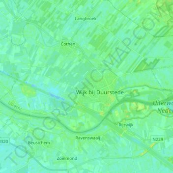
Name: Wijk bij Duurstede topographic map, elevation, terrain.
Location: Wijk bij Duurstede, Utrecht, Netherlands (51.95492 5.25627 52.00008 5.39495)
Average elevation: 5 m
Minimum elevation: -4 m
Maximum elevation: 15 m
Dutch Topographic map of the municipality of Wijk bij Duurstede, 2013.
Other topographic maps
Click on a map to view its topography, its elevation and its terrain.
Kromme Rijn
Netherlands > Utrecht > Wijk bij Duurstede
Kromme Rijn, Wijk bij Duurstede, Utrecht, Netherlands, 3945BN, Netherlands
Average elevation: 5 m