
Drongen topographic map
Interactive map
Click on the map to display elevation.
About this map
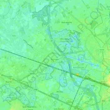
Name: Drongen topographic map, elevation, terrain.
Location: Drongen, Ghent, Gent, East Flanders, 9031, Belgium (51.02187 3.57976 51.08425 3.68508)
Average elevation: 7 m
Minimum elevation: -8 m
Maximum elevation: 19 m
Other topographic maps
Click on a map to view its topography, its elevation and its terrain.
Zwijnaarde
Belgium > East Flanders > Gent > Ghent
Zwijnaarde, Ghent, Gent, East Flanders, 9052, Belgium
Average elevation: 9 m
Afsnee
Belgium > East Flanders > Gent > Ghent
Afsnee, Ghent, Gent, East Flanders, Belgium
Average elevation: 7 m
Ghent
Belgium > East Flanders > Gent > Ghent
Ghent, Gent, East Flanders, Flanders, 24-32, Belgium
Average elevation: 12 m