
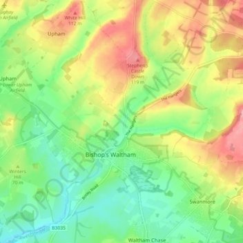
Bishop's Waltham topographic map
Interactive map
Click on the map to display elevation.
About this map
Name: Bishop's Waltham topographic map, elevation, terrain.
Average elevation: 62 m
Minimum elevation: 15 m
Maximum elevation: 127 m
Hampshire trails, hiking, mountain biking, running and outdoor activities
Other topographic maps
Click on a map to view its topography, its elevation and its terrain.
Beacon Hill Nature Reserve
United Kingdom > England > Hampshire > Winchester > Exton
Average elevation: 128 m
Store House Gully
United Kingdom > England > Hampshire > Winchester > Fisher's Pond
Average elevation: 45 m
Dodsley Wood
United Kingdom > England > Hampshire > Winchester > East Stratton
Average elevation: 99 m
Farley Chamberlayne
United Kingdom > England > Hampshire > Winchester > Hursley
Average elevation: 106 m
Brambridge
United Kingdom > England > Hampshire > Winchester > Colden Common > Brambridge
Average elevation: 37 m