
Bemidji topographic map
Interactive map
Click on the map to display elevation.
About this map
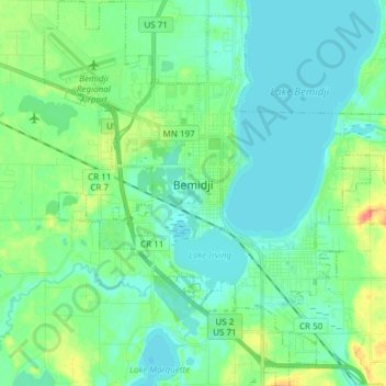
Name: Bemidji topographic map, elevation, terrain.
Location: Bemidji, Beltrami County, Minnesota, 56601, United States (47.42466 -94.94922 47.52695 -94.79998)
Average elevation: 417 m
Minimum elevation: 406 m
Maximum elevation: 453 m
Other topographic maps
Click on a map to view its topography, its elevation and its terrain.
Solway
United States > Minnesota > Beltrami County > Solway
Solway, Beltrami County, Minnesota, United States
Average elevation: 440 m
Bemidji
United States > Minnesota > Beltrami County > Bemidji
Bemidji, Beltrami County, Minnesota, 56601, United States
Average elevation: 416 m
Wilton
United States > Minnesota > Beltrami County
Wilton, Beltrami County, Minnesota, 56687, United States
Average elevation: 425 m