
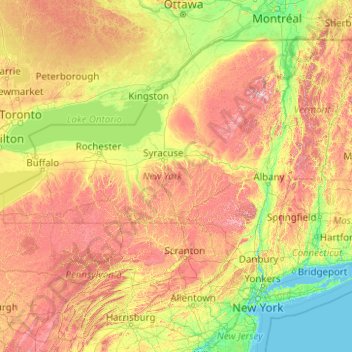
New York topographic map
Interactive map
Click on the map to display elevation.
About this map
Name: New York topographic map, elevation, terrain.
Location: New York, United States (40.47658 -79.76198 45.01586 -71.79097)
Average elevation: 278 m
Minimum elevation: -2 m
Maximum elevation: 1,436 m
New York has a diverse geography. The southeastern part of the state, the area known as Downstate, includes Long Island and several smaller associated islands, as well as New York City and the lower Hudson River Valley. The much larger Upstate New York area spreads from the Great Lakes to Lake Champlain, while its Southern tier region extends to the border of Pennsylvania; Upstate includes a diverse topography and range of regions including the Adirondack Mountains in the northeastern lobe of the state and the Catskill Mountains in the southwestern part of the state. New York also includes several ranges of the wider Appalachian Mountains. The east–west Mohawk River Valley is the primary river valley bisecting more mountainous regions, and connects to the north-south Hudson River valley in the Capital Region of New York. Western New York is part of the Great Lakes region and borders the Great Lakes of Lake Ontario and Lake Erie, as well as Niagara Falls. Between the central and western parts of the state, New York is dominated by the Finger Lakes, a popular vacation and tourist destination.
Other topographic maps
Click on a map to view its topography, its elevation and its terrain.
Brooklyn
United States > New York > New York
Brooklyn, Kings County, New York, United States
Average elevation: 9 m
Sarasota
United States > Florida > Sarasota County
Sarasota, Sarasota County, Florida, United States
Average elevation: 7 m
Appalachian Mountains
United States > North Carolina > Yancey County
Appalachian Mountains, Yancey County, North Carolina, United States
Average elevation: 1,463 m
Spokane
United States > Washington > Spokane County
Spokane, Spokane County, Washington, United States
Average elevation: 655 m
Madison
United States > Wisconsin > Dane County
Madison, Dane County, Wisconsin, United States
Average elevation: 284 m
Jacksonville
United States > Florida > Duval County
Jacksonville, Duval County, Florida, United States
Average elevation: 10 m
Sacramento
United States > California > Sacramento County
Sacramento, Sacramento County, California, United States
Average elevation: 10 m
Fairfax County
Fairfax County, Virginia, United States
Average elevation: 75 m
Allegheny County
Allegheny County, Pennsylvania, United States
Average elevation: 325 m
Albuquerque
United States > New Mexico > Bernalillo County
Albuquerque, Bernalillo County, New Mexico, United States
Average elevation: 1,688 m
Seattle
United States > Washington > King County
Seattle, King County, Washington, United States
Average elevation: 40 m
Central Park
United States > New York > New York County > New York
Central Park, New York County, New York, United States
Average elevation: 26 m
Palm Beach County
Palm Beach County, Florida, United States
Average elevation: 5 m
Santa Fe
United States > New Mexico > Santa Fe County
Santa Fe, Santa Fe County, New Mexico, United States
Average elevation: 2,221 m
Lancaster County
Lancaster County, Pennsylvania, United States
Average elevation: 158 m
Puget Sound
United States > Washington > Edmonds
Puget Sound, Admiral Way, Edmonds, Snohomish County, Washington, 98020, United States
Average elevation: 0 m