
Feusisberg topographic map
Interactive map
Click on the map to display elevation.
About this map
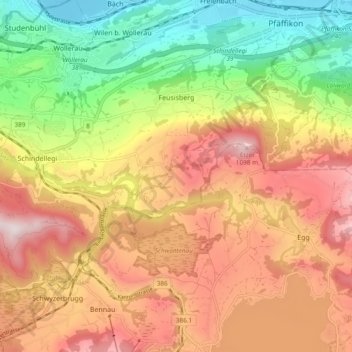
Name: Feusisberg topographic map, elevation, terrain.
Location: Feusisberg, Höfe, Schwyz, 8835, Schweiz (47.15027 8.69199 47.19438 8.78674)
Average elevation: 770 m
Minimum elevation: 402 m
Maximum elevation: 1,131 m
Die Gemeinde Feusisberg befindet sich auf einer Höhenterrasse am Etzel. Am Einschnitt, den die Sihl sich zwischen Etzel und Höhronen geschaffen hat, liegt der Ort Schindellegi. Ein Drittel der Gemeindefläche ist bewaldet.
Other topographic maps
Click on a map to view its topography, its elevation and its terrain.
Etzel
Schweiz > Schwyz > Höfe > Feusisberg
Etzel, Feusisberg, Höfe, Schwyz, 8835, Schweiz
Average elevation: 839 m
Pfäffikon
Schweiz > Schwyz > Höfe > Freienbach
Pfäffikon, Freienbach, Höfe, Schwyz, 8808, Schweiz
Average elevation: 569 m