Geolocate

Mbulu topographic map

Interactive map

Click on the map to display elevation.

About this map

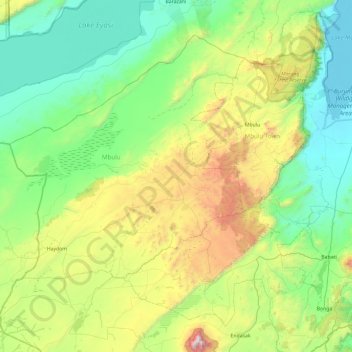
Name: Mbulu topographic map, elevation, terrain.

Location: Mbulu, Manyara, Northern Zone, Tanzania (-4.26323 34.78854 -3.72789 35.73336)

Average elevation: 1,523 m

Minimum elevation: 952 m

Maximum elevation: 3,324 m

Other topographic maps

Click on a map to view its topography, its elevation and its terrain.

Singu

Tanzania > Manyara > Singu

Singu, Babati Municipal, Manyara, Northern Zone, Tanzania

Average elevation: 1,676 m

Njoro

Tanzania > Manyara > Njoro

Njoro, Kiteto, Manyara, Northern Zone, Tanzania

Average elevation: 1,577 m

Hanang

Tanzania > Manyara

Hanang, Manyara, Northern Zone, 255, Tanzania

Average elevation: 1,593 m

Miomboni

Tanzania > Manyara > Miomboni

Miomboni, Babati, Manyara, Northern Zone, Tanzania

Average elevation: 1,395 m

Lake Manyara

Tanzania > Manyara

Lake Manyara, Babati, Manyara, Northern Zone, Tanzania

Average elevation: 1,174 m