
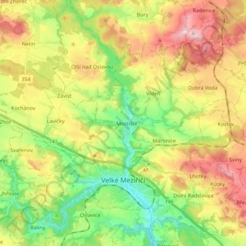
Velké Meziříčí topographic map
Interactive map
Click on the map to display elevation.
About this map
Name: Velké Meziříčí topographic map, elevation, terrain.
Average elevation: 523 m
Minimum elevation: 415 m
Maximum elevation: 662 m
Other topographic maps
Click on a map to view its topography, its elevation and its terrain.
Jihlava
Czechia > Southeast > Kraj Vysočina
Jihlava, okres Jihlava, Kraj Vysočina, Southeast, Czechia
Average elevation: 553 m
Střítež
Czechia > Southeast > Kraj Vysočina
Střítež, okres Jihlava, Kraj Vysočina, Southeast, 588 11, Czechia
Average elevation: 496 m
Hrotovice
Czechia > Southeast > Kraj Vysočina
Hrotovice, okres Třebíč, Kraj Vysočina, Southeast, 675 55, Czechia
Average elevation: 412 m
Rybníček
Czechia > Southeast > Kraj Vysočina
Rybníček, okres Havlíčkův Brod, Kraj Vysočina, Southeast, Czechia
Average elevation: 484 m
Humpolec
Czechia > Southeast > Kraj Vysočina
Humpolec, okres Pelhřimov, Kraj Vysočina, Southeast, Czechia
Average elevation: 555 m
Řehořov
Czechia > Southeast > Kraj Vysočina
Řehořov, Kamenice, okres Jihlava, Kraj Vysočina, Southeast, 588 24, Czechia
Average elevation: 590 m
Stařeč
Czechia > Southeast > Kraj Vysočina > Stařeč
Stařeč, okres Třebíč, Kraj Vysočina, Southeast, 675 22, Czechia
Average elevation: 499 m
Atmosférická stanice Košetice
Czechia > Southeast > Kraj Vysočina > Chýstovice
Atmosférická stanice Košetice, 112, Červův mlýn, Chýstovice, okres Pelhřimov, Kraj Vysočina, Southeast, 39422, Czechia
Average elevation: 522 m