
Riaba topographic map
Interactive map
Click on the map to display elevation.
About this map
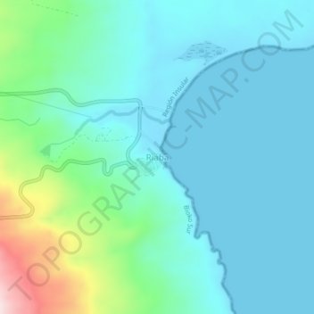
Name: Riaba topographic map, elevation, terrain.
Location: Riaba, Bioko Sud, Région Insulaire, Guinée équatoriale (3.36546 8.74297 3.40546 8.78297)
Average elevation: 74 m
Minimum elevation: 0 m
Maximum elevation: 396 m
Other topographic maps
Click on a map to view its topography, its elevation and its terrain.
Lubá
Guinée équatoriale > Bioko Sud > Lubá
Lubá, Bioko Sud, Région Insulaire, Guinée équatoriale
Average elevation: 160 m
Bioko
Guinée équatoriale > Bioko Sud
Bioko, Bioko Sud, Région Insulaire, 240, Guinée équatoriale
Average elevation: 301 m