
Middelharnis topographic map
Interactive map
Click on the map to display elevation.
About this map
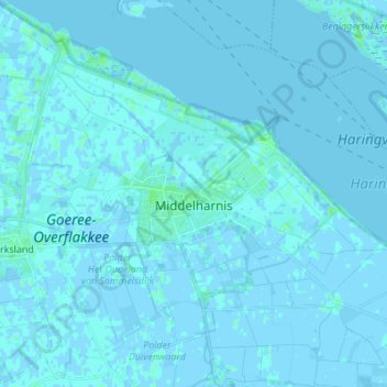
Name: Middelharnis topographic map, elevation, terrain.
Location: Middelharnis, Goeree-Overflakkee, Hollande-Méridionale, Pays-Bas (51.71793 4.14390 51.80238 4.26727)
Average elevation: 0 m
Minimum elevation: -4 m
Maximum elevation: 7 m
Other topographic maps
Click on a map to view its topography, its elevation and its terrain.
Goeree-Overflakkee
Pays-Bas > Hollande-Méridionale > Goeree-Overflakkee
Goeree-Overflakkee, Hollande-Méridionale, Pays-Bas
Average elevation: 0 m