
Široki Brijeg topographic map
Interactive map
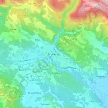
Click on the map to display elevation.
About this map
Name: Široki Brijeg topographic map, elevation, terrain.
Average elevation: 405 m
Minimum elevation: 234 m
Maximum elevation: 925 m
Neogenic layers are built of marl, sandy clay, sandstone and conglomerates, and can be found in the vicinity of Grabovo Drage and Mostarsko Blato. Quaternary banks of pebbles, sand and water karst saturated found on almost all rocky fields and drifts along the river beds. Between the lower mountain Vardi, Gvozd, Rujan and Trtle (altitude 600–900m) is a karstic depression Kočerinsko, Trnsko, Mokarsko and Ruževo field and Mostar Blato (altitude of 220–300m). Široki Brijeg area belongs to typical bauxite courts Lokve Black - Kidačke Njive, Resnica - deposit and Uzarići - Knešpolje. This area was devastated shoot landfills and tailings, and rehabilitation requirements.