
Culebra topographic map
Interactive map
Click on the map to display elevation.
Culebra
Culebra is characterized by an irregular topography resulting in a long intricate shoreline. The island is approximately 7 by 5 miles (11 by 8 km). The coast is marked by cliffs, sandy coral beaches and mangrove forests. Inland, the tallest point on the island is Mount Resaca, with an elevation of 636 ft (193.9 m), followed by Balcón Hill, with an elevation of 545 ft (166.1 m).
About this map
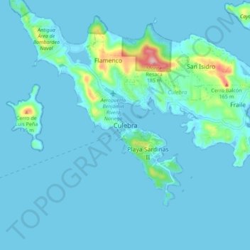
Name: Culebra topographic map, elevation, terrain.
Location: Culebra, Puerto Rico, 00775-0969, United States (18.26305 -65.34010 18.34305 -65.26010)
Average elevation: 16 m
Minimum elevation: -3 m
Maximum elevation: 188 m
Other topographic maps
Click on a map to view its topography, its elevation and its terrain.
Isla de Culebra
United States > Puerto Rico > Culebra > Culebra
Culebra is characterized by an irregular topography resulting in a long intricate shoreline. The island is approximately 7 by 5 miles (11 by 8 km). The coast is marked by cliffs, sandy coral beaches and mangrove forests. Inland, the tallest point on the island is Mount Resaca, with an elevation of 636 feet…
Average elevation: 11 m