
Csengele topographic map
Interactive map
Click on the map to display elevation.
About this map
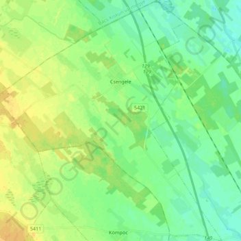
Name: Csengele topographic map, elevation, terrain.
Average elevation: 95 m
Minimum elevation: 86 m
Maximum elevation: 107 m
Other topographic maps
Click on a map to view its topography, its elevation and its terrain.
Mindszent
Hungary > Csongrád-Csanád County
Mindszent, Hódmezővásárhelyi járás, Csongrád-Csanád County, Southern Great Plain, Great Plain and North, 6630, Hungary
Average elevation: 80 m
Maros
Hungary > Csongrád-Csanád County > Apátfalva
Maros, Apátfalva, Makói járás, Csongrád-Csanád County, Southern Great Plain, Great Plain and North, 6931, Hungary
Average elevation: 86 m
Forráskút
Hungary > Csongrád-Csanád County > Forráskút
Forráskút, Mórahalmi járás, Csongrád-Csanád County, Southern Great Plain, Great Plain and North, 6793, Hungary
Average elevation: 94 m
Mórahalom
Hungary > Csongrád-Csanád County > Mórahalom
Mórahalom, Mórahalmi járás, Csongrád-Csanád County, Southern Great Plain, Great Plain and North, Hungary
Average elevation: 97 m
Makó
Hungary > Csongrád-Csanád County > Makó > Makó
Makó, Makói járás, Csongrád-Csanád County, Southern Great Plain, Great Plain and North, 6900, Hungary
Average elevation: 83 m
Csongrád
Hungary > Csongrád-Csanád County > Csongrád > Csongrád
Csongrád, Csongrádi járás, Csongrád-Csanád County, Southern Great Plain, Great Plain and North, 6640, Hungary
Average elevation: 82 m
Szeged
Hungary > Csongrád-Csanád County > Szeged
Szeged, Szegedi járás, Csongrád-Csanád County, Southern Great Plain, Great Plain and North, 6700, Hungary
Average elevation: 82 m
Maros
Hungary > Csongrád-Csanád County > Apátfalva
Maros, Apátfalva, Makói járás, Csongrád-Csanád County, Southern Great Plain, Great Plain and North, 6931, Hungary
Average elevation: 86 m
Ópusztaszer
Hungary > Csongrád-Csanád County > Ópusztaszer
Ópusztaszer, Kisteleki járás, Csongrád-Csanád County, Southern Great Plain, Great Plain and North, 6767, Hungary
Average elevation: 83 m