Geolocate

Drăgănești-Olt topographic map

Interactive map

Click on the map to display elevation.

About this map

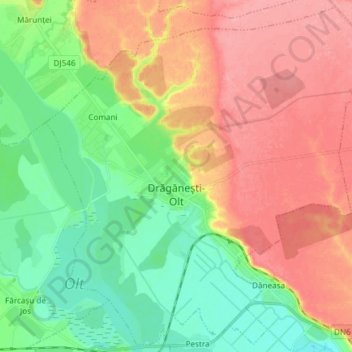
Name: Drăgănești-Olt topographic map, elevation, terrain.

Location: Drăgănești-Olt, Olt, Romania (44.12293 24.46656 44.22532 24.61533)

Average elevation: 101 m

Minimum elevation: 59 m

Maximum elevation: 148 m

The town is situated on the Wallachian Plain. It lies on the left bank of the river Olt, at an altitude of approximately 100 m (330 ft). It is located in the central part of Olt County, at a distance of 35 km (22 mi) from the county seat, Slatina, and 65 km (40 mi) north of Turnu Măgurele.

Wikipedia (CC-BY-SA 3.0)

Other topographic maps

Click on a map to view its topography, its elevation and its terrain.

Mardale

Romania > Olt

Mardale, Vulpeni, Olt, 237568, Romania

Average elevation: 186 m

Deveselu

Romania > Olt > Deveselu

Deveselu, Olt, 237130, Romania

Average elevation: 98 m

Vitomirești

Romania > Olt > Vitomirești

Vitomirești, Olt, 237545, Romania

Average elevation: 363 m

Corabia

Romania > Olt > Corabia

Corabia, Olt, Romania

Average elevation: 41 m

Caracal

Romania > Olt

Caracal, Olt, Romania

Average elevation: 109 m

Dăneasa

Romania > Olt > Dăneasa

Dăneasa, Olt, 237125, Romania

Average elevation: 90 m

Balș

Romania > Olt > Balș

Balș, Olt, Romania

Average elevation: 153 m

Slatina

Romania > Olt

Slatina, Olt, Romania

Average elevation: 148 m

Slatina

Romania > Olt

Slatina, Olt, Romania

Average elevation: 152 m