
MBEZI RIVER topographic map
Interactive map
Click on the map to display elevation.
About this map
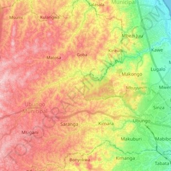
Name: MBEZI RIVER topographic map, elevation, terrain.
Location: MBEZI RIVER, Dar es Salaam, Coastal Zone, 34588 DSM, Tanzania (-6.80623 39.09670 -6.72485 39.23551)
Average elevation: 100 m
Minimum elevation: 0 m
Maximum elevation: 183 m
Other topographic maps
Click on a map to view its topography, its elevation and its terrain.
Luhanga
Tanzania > Coastal Zone > Dar es Salaam
Luhanga, Kisukuru, Dar es Salaam, Coastal Zone, Tanzania
Average elevation: 92 m