
Duncan topographic map
Interactive map
Click on the map to display elevation.
About this map
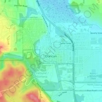
Name: Duncan topographic map, elevation, terrain.
Average elevation: 26 m
Minimum elevation: 2 m
Maximum elevation: 89 m
Other topographic maps
Click on a map to view its topography, its elevation and its terrain.
Ladysmith
Canada > British Columbia > Cowichan Valley Regional District
Ladysmith, Cowichan Valley Regional District, British Columbia, Canada
Average elevation: 202 m
North Cowichan
Canada > British Columbia > Cowichan Valley Regional District > North Cowichan
North Cowichan, Cowichan Valley Regional District, British Columbia, Canada
Average elevation: 180 m