
Mierzyno topographic map
Interactive map
Click on the map to display elevation.
About this map
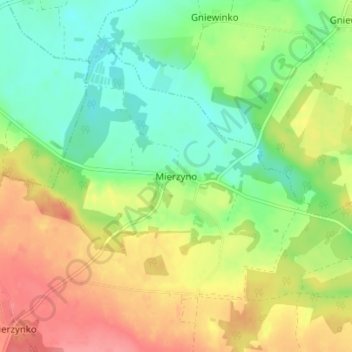
Name: Mierzyno topographic map, elevation, terrain.
Average elevation: 70 m
Minimum elevation: 36 m
Maximum elevation: 113 m
Other topographic maps
Click on a map to view its topography, its elevation and its terrain.
Orle
Poland > Pomeranian Voivodeship > Wejherowo County
Orle, gmina Wejherowo, Wejherowo County, Pomeranian Voivodeship, Poland
Average elevation: 43 m
Perlino-Wybudowa
Poland > Pomeranian Voivodeship > Wejherowo County > Perlino
Perlino-Wybudowa, Perlino, gmina Gniewino, Wejherowo County, Pomeranian Voivodeship, 84-250, Poland
Average elevation: 58 m
Sopieszyno
Poland > Pomeranian Voivodeship > Wejherowo County
Sopieszyno, gmina Wejherowo, Wejherowo County, Pomeranian Voivodeship, Poland
Average elevation: 148 m
Szemud
Poland > Pomeranian Voivodeship > Wejherowo County > Szemud
Szemud, gmina Szemud, Wejherowo County, Pomeranian Voivodeship, Poland
Average elevation: 186 m
Przetoczyno
Poland > Pomeranian Voivodeship > Wejherowo County > Przetoczyno
Przetoczyno, gmina Szemud, Wejherowo County, Pomeranian Voivodeship, Poland
Average elevation: 163 m
Rumia
Poland > Pomeranian Voivodeship > Wejherowo County > Rumia
Rumia, Wejherowo County, Pomeranian Voivodeship, 84-230, Poland
Average elevation: 69 m
Reda
Poland > Pomeranian Voivodeship > Wejherowo County > Reda
Reda, Wejherowo County, Pomeranian Voivodeship, 84-240, Poland
Average elevation: 46 m
Zbychowo
Poland > Pomeranian Voivodeship > Wejherowo County > Zbychowo
Zbychowo, gmina Wejherowo, Wejherowo County, Pomeranian Voivodeship, 84-206, Poland
Average elevation: 148 m
Wejherowo
Poland > Pomeranian Voivodeship > Wejherowo County > Wejherowo
Wejherowo, Wejherowo County, Pomeranian Voivodeship, Poland
Average elevation: 71 m