
Sierre topographic map
Interactive map
Click on the map to display elevation.
About this map
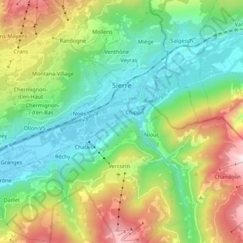
Name: Sierre topographic map, elevation, terrain.
Location: Sierre, Wallis, 3960, Switzerland (46.24568 7.42848 46.30711 7.58061)
Average elevation: 1,143 m
Minimum elevation: 500 m
Maximum elevation: 2,563 m
The hilly topography of the valley floor derives from a very large postglacial rock avalanche, which collapsed from a fractured scar high to the north.
Other topographic maps
Click on a map to view its topography, its elevation and its terrain.
Lac de Chermignon
Switzerland > Wallis > Sierre > Plans-Mayens
Lac de Chermignon, Plans-Mayens, Lens, Sierre, Wallis, 3960, Switzerland
Average elevation: 1,548 m
Lac de Châteaupré
Switzerland > Wallis > Sierre > Anniviers
Lac de Châteaupré, Anniviers, Sierre, Wallis, 3961, Switzerland
Average elevation: 2,646 m
Crans-Montana
Switzerland > Wallis > Sierre
Crans-Montana, Sierre, Wallis, 3960, Switzerland
Average elevation: 1,660 m
Zinal
Switzerland > Wallis > Sierre > Anniviers
Zinal, Anniviers, Sierre, Wallis, 3961, Switzerland
Average elevation: 2,209 m
Chandolin
Switzerland > Wallis > Sierre > Anniviers
Chandolin, Anniviers, Sierre, Wallis, 3961, Switzerland
Average elevation: 1,901 m
Randogne
Switzerland > Wallis > Sierre > Crans-Montana
Randogne, Crans-Montana, Sierre, Wallis, 3960, Switzerland
Average elevation: 1,614 m
Couronne de Bréona
Switzerland > Wallis > Sierre > Anniviers
Couronne de Bréona, Anniviers, Sierre, Wallis, 3961, Switzerland
Average elevation: 2,720 m