
Wuhou District topographic map
Interactive map
Click on the map to display elevation.
About this map
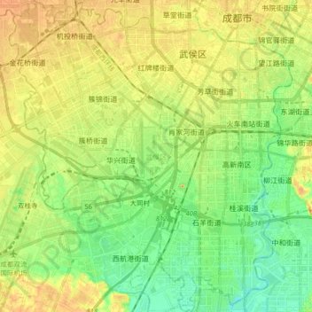
Name: Wuhou District topographic map, elevation, terrain.
Location: Wuhou District, Chengdu City, Sichuan, PRC (30.52871 103.94547 30.66717 104.09175)
Average elevation: 493 m
Minimum elevation: 469 m
Maximum elevation: 522 m
Other topographic maps
Click on a map to view its topography, its elevation and its terrain.
Jialing River
Jialing River, Gaoping District, Nanchong City, Sichuan, 400000, PRC
Average elevation: 516 m
Hanshui River
Hanshui River, Dachuan District, Dazhou City, Sichuan, PRC
Average elevation: 423 m