
Kelheim topographic map
Interactive map
Click on the map to display elevation.
About this map
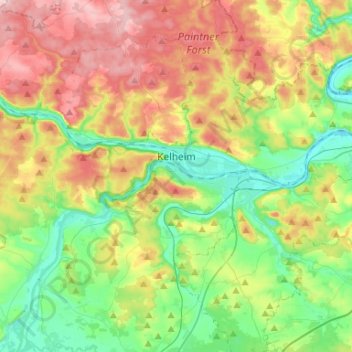
Name: Kelheim topographic map, elevation, terrain.
Location: Kelheim, Landkreis Kelheim, Bavaria, 93309, Germany (48.85376 11.71682 48.96464 12.01354)
Average elevation: 423 m
Minimum elevation: 334 m
Maximum elevation: 570 m
Other topographic maps
Click on a map to view its topography, its elevation and its terrain.
Offenstetten
Germany > Bavaria > Landkreis Kelheim
Offenstetten, Abensberg, Landkreis Kelheim, Bavaria, 93348, Germany
Average elevation: 385 m
Mauern
Germany > Bavaria > Landkreis Kelheim > Neustadt an der Donau
Mauern, Neustadt an der Donau, Landkreis Kelheim, Bavaria, 93333, Germany
Average elevation: 353 m
Paring
Germany > Bavaria > Landkreis Kelheim > Paring
Paring, Langquaid, Langquaid (VGem), Landkreis Kelheim, Bavaria, 84085, Germany
Average elevation: 404 m
Mainburg
Germany > Bavaria > Landkreis Kelheim
Mainburg, Landkreis Kelheim, Bavaria, 84048, Germany
Average elevation: 456 m