
Raron topographic map
Interactive map
Click on the map to display elevation.
About this map
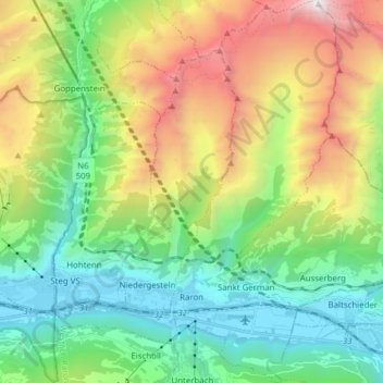
Name: Raron topographic map, elevation, terrain.
Location: Raron, Westlich Raron, Wallis, 3942, Switzerland (46.28610 7.79090 46.39262 7.85931)
Average elevation: 1,712 m
Minimum elevation: 625 m
Maximum elevation: 3,908 m
Other topographic maps
Click on a map to view its topography, its elevation and its terrain.
Blatten
Switzerland > Wallis > Westlich Raron
Blatten, Westlich Raron, Wallis, 3919, Switzerland
Average elevation: 2,536 m
Grosshorn
Switzerland > Wallis > Westlich Raron > Blatten
Grosshorn, Blatten, Westlich Raron, Wallis, 3919, Switzerland
Average elevation: 3,073 m
Lauchernalp
Switzerland > Wallis > Westlich Raron
Lauchernalp, Wiler (Lötschen), Westlich Raron, Wallis, 3918, Switzerland
Average elevation: 1,956 m
Breithorn
Switzerland > Wallis > Westlich Raron > Blatten
Breithorn, Blatten, Westlich Raron, Wallis, 3919, Switzerland
Average elevation: 2,914 m