
Lake Managua topographic map
Interactive map
Click on the map to display elevation.
About this map
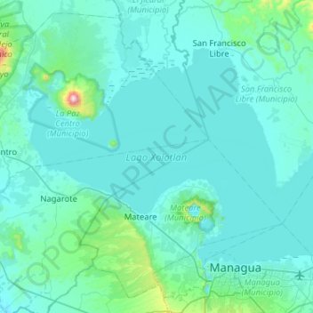
Name: Lake Managua topographic map, elevation, terrain.
Location: Lake Managua, Leon, 11000, Nicaragua (12.15657 -86.61169 12.49980 -86.09945)
Average elevation: 101 m
Minimum elevation: 22 m
Maximum elevation: 1,270 m
The lake rose 3 metres (10 ft) in five days during Hurricane Mitch in 1998, destroying the homes of many who lived on its edge. An even higher flooding occurred in September/October 2010. Since then, the city has prohibited residential use of the most flood-prone areas, those with the elevation below 42.76 meters above sea level.
Other topographic maps
Click on a map to view its topography, its elevation and its terrain.
El Bordo
Nicaragua > Leon > El Jicaral
El Bordo, El Jicaral, Leon, 22600, Nicaragua
Average elevation: 412 m
Leon (Municipality)
Leon (Municipality), Leon, 21000, Nicaragua
Average elevation: 61 m