
Cornish topographic map
Interactive map
Click on the map to display elevation.
About this map
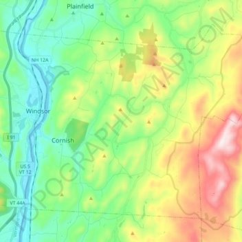
Name: Cornish topographic map, elevation, terrain.
Location: Cornish, Sullivan County, New Hampshire, United States (43.42379 -72.39912 43.52518 -72.22558)
Average elevation: 272 m
Minimum elevation: 83 m
Maximum elevation: 945 m
According to the United States Census Bureau, the town has a total area of 42.6 square miles (110.4 km2), of which 42.0 square miles (108.7 km2) are land and 0.66 square miles (1.7 km2) are water, comprising 1.54% of the town. The Connecticut River forms the western boundary of the town, which is also the New Hampshire–Vermont border. The town is drained by direct tributaries of the Connecticut: Blow-me-down Brook, Mill Brook, and Walker Brook; and by Redwater Brook, which flows south to the Sugar River in Claremont before that river joins the Connecticut. The long ridge of Croydon Mountain follows the eastern boundary of town; the highest point in town is a knob on Croydon Mountain which reaches an elevation of 2,323 ft (708 m) above sea level. The eastern part of the town is a portion of the approximately 25,000-acre (100 km2) Blue Mountain Forest Association private game preserve, also known locally as Corbin Park, named after its founder, Austin Corbin.
Other topographic maps
Click on a map to view its topography, its elevation and its terrain.
East Unity
United States > New Hampshire > Sullivan County > Unity
East Unity, Unity, Sullivan County, New Hampshire, United States
Average elevation: 399 m
Sunapee
United States > New Hampshire > Sullivan County
Sunapee, Sullivan County, New Hampshire, United States
Average elevation: 363 m
Croydon
United States > New Hampshire > Sullivan County
Croydon, Sullivan County, New Hampshire, United States
Average elevation: 372 m
Newport
United States > New Hampshire > Sullivan County
Newport, Sullivan County, New Hampshire, United States
Average elevation: 339 m
Ryder Corner
United States > New Hampshire > Sullivan County > Croydon
Ryder Corner, Croydon, Sullivan County, New Hampshire, 03754, United States
Average elevation: 352 m
Grantham
United States > New Hampshire > Sullivan County
Grantham, Sullivan County, New Hampshire, 03753, United States
Average elevation: 419 m
Unity
United States > New Hampshire > Sullivan County
Unity, Sullivan County, New Hampshire, United States
Average elevation: 369 m
Green Mountain
United States > New Hampshire > Sullivan County > Claremont
Green Mountain, Claremont, Sullivan County, New Hampshire, United States
Average elevation: 446 m
Goshen
United States > New Hampshire > Sullivan County > Goshen
Goshen, Sullivan County, New Hampshire, 03752, United States
Average elevation: 419 m
Eastman
United States > New Hampshire > Sullivan County > Grantham > Eastman
Eastman, Grantham, Sullivan County, New Hampshire, 03753, United States
Average elevation: 347 m
Acworth
United States > New Hampshire > Sullivan County
Acworth, Sullivan County, New Hampshire, 03601, United States
Average elevation: 380 m
Langdon
United States > New Hampshire > Sullivan County
Langdon, Sullivan County, New Hampshire, United States
Average elevation: 239 m
Mill Hollow
United States > New Hampshire > Sullivan County > Plainfield > Mill Hollow
Mill Hollow, Plainfield, Sullivan County, New Hampshire, 03770, United States
Average elevation: 313 m
Lempster
United States > New Hampshire > Sullivan County
Lempster, Sullivan County, New Hampshire, 03605, United States
Average elevation: 425 m
North Grantham
United States > New Hampshire > Sullivan County > Grantham > North Grantham
North Grantham, Grantham, Sullivan County, New Hampshire, 03753, United States
Average elevation: 386 m
Charlestown
United States > New Hampshire > Sullivan County
Charlestown, Sullivan County, New Hampshire, 03603, United States
Average elevation: 256 m
Claremont
United States > New Hampshire > Sullivan County
Claremont, Sullivan County, New Hampshire, United States
Average elevation: 236 m
Plainfield
United States > New Hampshire > Sullivan County > Plainfield
Plainfield, Sullivan County, New Hampshire, United States
Average elevation: 267 m