
Mae Sot topographic map
Interactive map
Click on the map to display elevation.
About this map
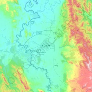
Name: Mae Sot topographic map, elevation, terrain.
Location: Mae Sot, Tak Province, 63110, Thailand (16.55499 98.40955 16.87499 98.72955)
Average elevation: 339 m
Minimum elevation: 170 m
Maximum elevation: 920 m
Other topographic maps
Click on a map to view its topography, its elevation and its terrain.
Ban Pueng Klueng
Thailand > Tak Province > Ban Pueng Klueng
Ban Pueng Klueng, Tak Province, Thailand
Average elevation: 201 m
Huai Bong
Thailand > Tak Province > Ban Huai Bong
Huai Bong, Ban Huai Bong, Tak Province, Thailand
Average elevation: 195 m
Ban Mon Hin Lek Fai
Thailand > Tak Province > Ban Mon Hin Lek Fai
Ban Mon Hin Lek Fai, Tak Province, Thailand
Average elevation: 519 m