
Morges topographic map
Interactive map
Click on the map to display elevation.
About this map
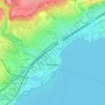
Name: Morges topographic map, elevation, terrain.
Location: Morges, District de Morges, Vaud, 1110, Switzerland (46.50102 6.47651 46.52375 6.51347)
Average elevation: 396 m
Minimum elevation: 370 m
Maximum elevation: 478 m
Other topographic maps
Click on a map to view its topography, its elevation and its terrain.
Cossonay
Switzerland > Vaud > District de Morges
Cossonay, District de Morges, Vaud, 1304, Switzerland
Average elevation: 533 m
Saint-Prex
Switzerland > Vaud > District de Morges
Saint-Prex, District de Morges, Vaud, 1162, Switzerland
Average elevation: 398 m
Mont Tendre
Switzerland > Vaud > District de Morges > Montricher
Mont Tendre, Montricher, District de Morges, Vaud, 1147, Switzerland
Average elevation: 1,508 m
Morges
Switzerland > Vaud > District de Morges > Morges > Morges
Morges, District de Morges, Vaud, 1110, Switzerland
Average elevation: 418 m