
Saint-Ghislain topographic map
Interactive map
Click on the map to display elevation.
About this map
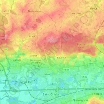
Name: Saint-Ghislain topographic map, elevation, terrain.
Location: Saint-Ghislain, Mons, Hainaut, Wallonia, Belgium (50.43816 3.73652 50.54153 3.87945)
Average elevation: 54 m
Minimum elevation: 14 m
Maximum elevation: 99 m
Other topographic maps
Click on a map to view its topography, its elevation and its terrain.
Colfontaine
Colfontaine, Mons, Hainaut, Wallonia, 7340, Belgium
Average elevation: 91 m