
Queenstown-Lakes District topographic map
Interactive map
Click on the map to display elevation.
About this map
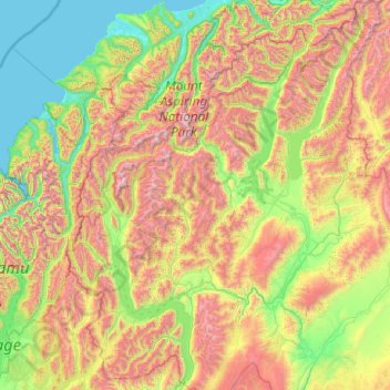
Name: Queenstown-Lakes District topographic map, elevation, terrain.
Location: Queenstown-Lakes District, Otago, New Zealand (-45.36757 168.11639 -43.95541 169.71978)
Average elevation: 832 m
Minimum elevation: -1 m
Maximum elevation: 2,819 m
Other topographic maps
Click on a map to view its topography, its elevation and its terrain.
Mount Head
New Zealand > Otago > Queenstown-Lakes District
Mount Head, Queenstown-Lakes District, Otago, New Zealand
Average elevation: 1,992 m
Kakanui
New Zealand > Otago > Waitaki District
Kakanui, Waitaki District, Otago, 9495, New Zealand
Average elevation: 10 m
Dicks Hill
New Zealand > Otago > Dunedin City
Dicks Hill, Dunedin City, Otago, 9014, New Zealand
Average elevation: 128 m
Devils Bridge
New Zealand > Otago > Waitaki District
Devils Bridge, Waitaki District, Otago, 9492, New Zealand
Average elevation: 136 m
Queenstown Hill
New Zealand > Otago > Queenstown-Lakes District > Queenstown
Queenstown Hill, Queenstown, Queenstown-Lakes District, Otago, 9300, New Zealand
Average elevation: 700 m
Kauru
New Zealand > Otago > Waitaki District
Kauru, Waitaki District, Otago, New Zealand
Average elevation: 264 m
Prince of Wales
New Zealand > Otago > Queenstown-Lakes District
Prince of Wales, Queenstown-Lakes District, Otago, New Zealand
Average elevation: 1,274 m
Cromwell Community
New Zealand > Otago > Central Otago District
Cromwell Community, Central Otago District, Otago, New Zealand
Average elevation: 876 m
Central Otago
New Zealand > Otago > Central Otago District > Vincent Community
Central Otago, Vincent Community, Central Otago District, Otago, 9035, New Zealand
Average elevation: 935 m
Mount Charles
New Zealand > Otago > Dunedin City
Mount Charles, Dunedin City, Otago, New Zealand
Average elevation: 117 m
Roys Peak
New Zealand > Otago > Queenstown-Lakes District
Roys Peak, Queenstown-Lakes District, Otago, New Zealand
Average elevation: 1,099 m
Coronet Peak
New Zealand > Otago > Queenstown-Lakes District
Coronet Peak, Queenstown-Lakes District, Otago, New Zealand
Average elevation: 1,304 m
Cardrona
New Zealand > Otago > Queenstown-Lakes District
Cardrona, Queenstown-Lakes District, Otago, New Zealand
Average elevation: 758 m
Dunedin
New Zealand > Otago > Dunedin City
Dunedin, Dunedin City, Otago, 9054, New Zealand
Average elevation: 110 m
Waiareka Junction
New Zealand > Otago > Waitaki District > Oamaru > Waiareka Junction
Waiareka Junction, Oamaru, Waitaki District, Otago, 9401, New Zealand
Average elevation: 63 m
Middlemarch
New Zealand > Otago > Dunedin City > Middlemarch
Middlemarch, Dunedin City, Otago, 9597, New Zealand
Average elevation: 210 m
Wānaka
New Zealand > Otago > Queenstown-Lakes District
Wānaka, Queenstown-Lakes District, Otago, 9305, New Zealand
Average elevation: 381 m
Cromwell
New Zealand > Otago > Central Otago District > Cromwell Community > Cromwell
Cromwell, Cromwell Community, Central Otago District, Otago, 9310, New Zealand
Average elevation: 330 m
Roxburgh
New Zealand > Otago > Central Otago District > Teviot Valley Community
Roxburgh, Teviot Valley Community, Central Otago District, Otago, 9500, New Zealand
Average elevation: 223 m
Waiwera River
New Zealand > Otago > Clutha District
Waiwera River, Clutha District, Otago, New Zealand
Average elevation: 64 m
Karitane
New Zealand > Otago > Dunedin City
Karitane, Dunedin City, Otago, 9510, New Zealand
Average elevation: 18 m
Glendhu Bay
New Zealand > Otago > Queenstown-Lakes District
Glendhu Bay, Queenstown-Lakes District, Otago, New Zealand
Average elevation: 406 m