
Bostanlik district topographic map
Interactive map
Click on the map to display elevation.
About this map
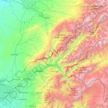
Name: Bostanlik district topographic map, elevation, terrain.
Location: Bostanlik district, Tashkent Region, Uzbekistan (41.22391 69.58633 42.29508 71.26909)
Average elevation: 1,596 m
Minimum elevation: 300 m
Maximum elevation: 4,269 m
The relief of the Bostanliq district is relatively monotonous and is represented mainly by hills, mountains and high mountains. Lowlands are widespread in the western and part of the southern part of the region, adyrs are widespread except in the northern part, where there are only high mountains. Almost all the territory where the high mountain systems, the eastern Tien Shan, the Karzhantau ridge, the Pskem Mountains, the Ugam ridge and the Chatkal ridge are located, is occupied by mountains. The heights in the district accordingly increase in direction from west to east and from south to north. The southern and western parts of the region are on average 1000 meters above sea level. The rest of the region where the highlands prevail, is located at an altitude of 1,200 to 4,000 meters above sea level. The highest point of the area is the peak of the Adelung Pskem ridge with an altitude of 4301 meters. In the second place in height, the mountain is another peak of the Pskem ridge - Beshtor with a height of 4299 meters. In addition to the peaks and peaks listed above, there are many high mountains and peaks in the district, which are between 1,000 and 4,000 meters above sea level. The largest and most significant peaks and peaks of the region: Aktash, Big Chimgan, Kyzylnur, Mingbulak, Pulatkhan and others. Car passes pass through many relatively high mountains. The hills are formed mainly by sandstones and loess. The foot of many mountains are mainly composed of slate and granite. The territory of the region is included in a seismic zone and annually from 5 to 8 or more earthquakes of various types occur in the region.[4]
Other topographic maps
Click on a map to view its topography, its elevation and its terrain.
Amirsay
Uzbekistan > Tashkent Region > Bostanlik district
Amirsay, Bostanlik district, Tashkent Region, Uzbekistan
Average elevation: 1,626 m
Beshyuz
Beshyuz, Bekobod district, Tashkent Region, Uzbekistan
Average elevation: 293 m
Piskent district
Piskent district, Tashkent Region, Uzbekistan
Average elevation: 724 m
Sergeli
Uzbekistan > Tashkent Region > Yukorichirchik district
Sergeli, Yukorichirchik district, Tashkent Region, 111907, Uzbekistan
Average elevation: 548 m
Uzunbulak
Uzbekistan > Tashkent Region > Ohangaron Tumani
Uzunbulak, Ohangaron Tumani, Tashkent Region, Uzbekistan
Average elevation: 1,274 m
Gulabad
Uzbekistan > Tashkent Region > Ohangaron Tumani
Gulabad, Ohangaron Tumani, Tashkent Region, Uzbekistan
Average elevation: 529 m
Aksy
Uzbekistan > Tashkent Region > Ohangaron Tumani
Aksy, Ohangaron Tumani, Tashkent Region, Uzbekistan
Average elevation: 2,479 m
Tutamgaly
Uzbekistan > Tashkent Region > Parkent district
Tutamgaly, Parkent district, Tashkent Region, Uzbekistan
Average elevation: 1,409 m
Koʻksuv
Uzbekistan > Tashkent Region > Bostanlik district
Koʻksuv, Bostanlik district, Tashkent Region, Uzbekistan
Average elevation: 2,285 m
X лет Узб ССР
Uzbekistan > Tashkent Region > Buka district
X лет Узб ССР, Buka district, Tashkent Region, Uzbekistan
Average elevation: 309 m
Sukok
Uzbekistan > Tashkent Region > Parkent district
Sukok, Parkent district, Tashkent Region, Uzbekistan
Average elevation: 1,148 m
Tuyabuguz
Uzbekistan > Tashkent Region > Yukorichirchik district
Tuyabuguz, Yukorichirchik district, Tashkent Region, Uzbekistan
Average elevation: 390 m
Yusufhana
Uzbekistan > Tashkent Region > Bostanlik district
Yusufhana, Bostanlik district, Tashkent Region, Uzbekistan
Average elevation: 923 m
Nazarbek
Uzbekistan > Tashkent Region > Zangiota Tumani
Nazarbek, Zangiota Tumani, Tashkent Region, 111812, Uzbekistan
Average elevation: 411 m
Daliguzor
Uzbekistan > Tashkent Region > Zangiota Tumani
Daliguzor, Zangiota Tumani, Tashkent Region, Uzbekistan
Average elevation: 409 m
Angren
Uzbekistan > Tashkent Region > Ohangaron Tumani > Angren
Angren, Ohangaron Tumani, Tashkent Region, Uzbekistan
Average elevation: 1,047 m
Samarkand
Uzbekistan > Tashkent Region > Buka district > Samarkand
Samarkand, Buka district, Tashkent Region, Uzbekistan
Average elevation: 295 m
Iskander
Iskander, Bostanlik district, Tashkent Region, 101200, Uzbekistan
Average elevation: 749 m
Parkent district
Parkent district, Tashkent Region, Uzbekistan
Average elevation: 942 m
Ugam
Ugam, Bostanlik district, Tashkent Region, Uzbekistan
Average elevation: 1,017 m
Bekabad
Uzbekistan > Tashkent Region > Bekabad
Bekabad, Tashkent Region, Uzbekistan
Average elevation: 317 m
Beshtut
Uzbekistan > Tashkent Region > Beshtut
Beshtut, Bostanlik district, Tashkent Region, Uzbekistan
Average elevation: 895 m
Akmola
Uzbekistan > Tashkent Region > Yukorichirchik district
Akmola, Yukorichirchik district, Tashkent Region, Uzbekistan
Average elevation: 456 m
Chimgan
Uzbekistan > Tashkent Region > Bostanlik district
Chimgan, Bostanlik district, Tashkent Region, Uzbekistan
Average elevation: 1,488 m