
Harthill topographic map
Interactive map
Click on the map to display elevation.
About this map
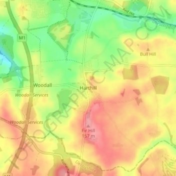
Name: Harthill topographic map, elevation, terrain.
Average elevation: 116 m
Minimum elevation: 69 m
Maximum elevation: 155 m
Harthill is a village in the Metropolitan Borough of Rotherham (part of South Yorkshire, England), on the border with Derbyshire. It lies between Killamarsh and Thorpe Salvin, and is located at approximately 53°19′10″N 1°15′30″W / 53.31944°N 1.25833°W / 53.31944; -1.25833, at an elevation of around 110 metres above sea level. In the 2001 census, the civil parish of Harthill with Woodall had a population of 1,909,[1] reducing slightly to 1,879 at the 2011 Census.[2]
Other topographic maps
Click on a map to view its topography, its elevation and its terrain.
South Anston
United Kingdom > England > Rotherham
South Anston, Rotherham, South Yorkshire, England, S25 5DT, United Kingdom
Average elevation: 105 m
Aston
United Kingdom > England > Rotherham
Aston, Rotherham, South Yorkshire, England, S26 2AP, United Kingdom
Average elevation: 89 m
Waverley
United Kingdom > England > Rotherham
Waverley, Rotherham, South Yorkshire, England, S60 8AH, United Kingdom
Average elevation: 65 m
Greasbrough
United Kingdom > England > Rotherham
Greasbrough, Rotherham, South Yorkshire, England, S61 4ES, United Kingdom
Average elevation: 69 m
Hellaby
United Kingdom > England > Rotherham
Hellaby, Rotherham, South Yorkshire, England, United Kingdom
Average elevation: 113 m
North Anston
United Kingdom > England > Rotherham
North Anston, Rotherham, South Yorkshire, England, S25 4AL, United Kingdom
Average elevation: 106 m
Wickersley
United Kingdom > England > Rotherham > Bramley
Wickersley, Bramley, Rotherham, South Yorkshire Mayoral Combined Authority, England, United Kingdom
Average elevation: 116 m
Aughton
United Kingdom > England > Rotherham
Ulley, Aughton, Rotherham, South Yorkshire Mayoral Combined Authority, England, United Kingdom
Average elevation: 92 m
Bramley
United Kingdom > England > Rotherham
Bramley, Rotherham, South Yorkshire Mayoral Combined Authority, England, S66 2RT, United Kingdom
Average elevation: 116 m
Sheffield and South Yokshire Navigation
United Kingdom > England > Rotherham > Thrybergh
Sheffield and South Yokshire Navigation, Thrybergh, Rotherham, South Yorkshire Mayoral Combined Authority, England, S64 5TH, United Kingdom
Average elevation: 39 m
Thrybergh
United Kingdom > England > Rotherham
Thrybergh, Rotherham, South Yorkshire, England, United Kingdom
Average elevation: 48 m
Ravenfield
United Kingdom > England > Rotherham
Ravenfield, Bramley, Rotherham, South Yorkshire, England, United Kingdom
Average elevation: 86 m
Thurcroft
United Kingdom > England > Rotherham > Thurcroft
Thurcroft, Rotherham, South Yorkshire, England, United Kingdom
Average elevation: 111 m
Kiveton Park
United Kingdom > England > Rotherham
Kiveton Park, Rotherham, South Yorkshire, England, S26 6SE, United Kingdom
Average elevation: 104 m
Morthen
United Kingdom > England > Rotherham
Morthen, Rotherham, South Yorkshire Mayoral Combined Authority, England, S66 9JH, United Kingdom
Average elevation: 103 m
Todwick
United Kingdom > England > Rotherham > Todwick
Todwick, Rotherham, South Yorkshire Mayoral Combined Authority, England, United Kingdom
Average elevation: 105 m
Anston Stones Wood
United Kingdom > England > Rotherham > North Anston
Anston Stones Wood, North and South Anston, North Anston, Rotherham, South Yorkshire Mayoral Combined Authority, England, United Kingdom
Average elevation: 102 m
Brinsworth
United Kingdom > England > Rotherham > Catcliffe
Brinsworth, Catcliffe, Rotherham, South Yorkshire Mayoral Combined Authority, England, United Kingdom
Average elevation: 53 m
Treeton
United Kingdom > England > Rotherham
Treeton, Rotherham, South Yorkshire, England, S60 5PP, United Kingdom
Average elevation: 58 m
Carr
United Kingdom > England > Rotherham > Laughton-en-le-Morthen > Carr
Carr, Laughton-en-le-Morthen, Rotherham, Yorkshire and the Humber, England, S66 8PW, United Kingdom
Average elevation: 112 m
Bradgate Park
United Kingdom > England > Rotherham
Bradgate Park, Bradgate, Rotherham, Yorkshire and the Humber, England, United Kingdom
Average elevation: 69 m
Swallownest
United Kingdom > England > Rotherham
Swallownest, Rotherham, South Yorkshire Mayoral Combined Authority, England, S26 4TT, United Kingdom
Average elevation: 72 m
Aughton
United Kingdom > England > Rotherham
Aughton, Rotherham, South Yorkshire Mayoral Combined Authority, England, S26 3XH, United Kingdom
Average elevation: 77 m
Guilthwaite
United Kingdom > England > Rotherham
Whiston, Guilthwaite, Rotherham, South Yorkshire Mayoral Combined Authority, England, United Kingdom
Average elevation: 72 m
Woodall
United Kingdom > England > Rotherham > Woodall
Woodall, Rotherham, Yorkshire and the Humber, England, S26 7UN, United Kingdom
Average elevation: 109 m
Wales
United Kingdom > England > Rotherham
Wales, Rotherham, South Yorkshire Mayoral Combined Authority, England, S26 5RT, United Kingdom
Average elevation: 95 m
Fir Hill
United Kingdom > England > Rotherham
Fir Hill, Rotherham, Yorkshire and the Humber, England, S26 7YP, United Kingdom
Average elevation: 126 m
Aston cum Aughton
United Kingdom > England > Rotherham
Aston cum Aughton, Rotherham, Yorkshire and the Humber, England, United Kingdom
Average elevation: 78 m
Firbeck
United Kingdom > England > Rotherham
Firbeck, Rotherham, South Yorkshire, England, United Kingdom
Average elevation: 62 m
Thorpe Hesley
United Kingdom > England > Rotherham
Thorpe Hesley, Rotherham, South Yorkshire, England, S61 2QG, United Kingdom
Average elevation: 100 m