
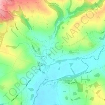
Ellastone topographic map
Interactive map
Click on the map to display elevation.
About this map
Name: Ellastone topographic map, elevation, terrain.
Average elevation: 139 m
Minimum elevation: 90 m
Maximum elevation: 228 m
Other topographic maps
Click on a map to view its topography, its elevation and its terrain.
Uttoxeter
United Kingdom > England > East Staffordshire > Uttoxeter
Uttoxeter, Staffordshire, West Midlands, England, ST14 8HF, United Kingdom
Average elevation: 108 m
Tutbury Castle
United Kingdom > England > East Staffordshire
Tutbury Castle, Castle Street, Tutbury, East Staffordshire, Staffordshire, West Midlands, England, DE13 9JF, United Kingdom
Average elevation: 66 m
Tutbury
United Kingdom > England > East Staffordshire > Tutbury
Tutbury, East Staffordshire, Staffordshire, West Midlands, England, DE13 9LS, United Kingdom
Average elevation: 66 m
Wootton
United Kingdom > England > East Staffordshire > Wootton
Wootton, East Staffordshire, Staffordshire, West Midlands, England, DE6 2GW, United Kingdom
Average elevation: 217 m
Wychnor
United Kingdom > England > East Staffordshire > Wychnor
Wychnor, East Staffordshire, Staffordshire, West Midlands, England, DE13 8BY, United Kingdom
Average elevation: 58 m
Hanbury
United Kingdom > England > East Staffordshire > Hanbury
Hanbury, East Staffordshire, Staffordshire, West Midlands, England, DE13 8TP, United Kingdom
Average elevation: 104 m
Dunstall
United Kingdom > England > East Staffordshire > Dunstall
Dunstall, East Staffordshire, Staffordshire, West Midlands, England, United Kingdom
Average elevation: 79 m
Denstone
United Kingdom > England > East Staffordshire > Denstone
Denstone, East Staffordshire, Staffordshire, West Midlands, England, ST14 5GB, United Kingdom
Average elevation: 118 m
Rolleston on Dove
United Kingdom > England > East Staffordshire > Rolleston on Dove
Rolleston on Dove, East Staffordshire, Staffordshire, West Midlands, England, DE13 9BE, United Kingdom
Average elevation: 60 m
River Tean
United Kingdom > England > East Staffordshire
River Tean, East Staffordshire, Staffordshire, West Midlands, England, ST14 5AA, United Kingdom
Average elevation: 89 m
Winshill
United Kingdom > England > East Staffordshire
Winshill, East Staffordshire, Staffordshire, West Midlands, England, United Kingdom
Average elevation: 75 m
River Swarbourn
United Kingdom > England > East Staffordshire
River Swarbourn, East Staffordshire, Staffordshire, West Midlands, England, DE13 8RU, United Kingdom
Average elevation: 98 m