
Biankouma topographic map
Interactive map
Click on the map to display elevation.
About this map
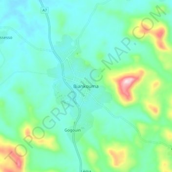
Name: Biankouma topographic map, elevation, terrain.
Location: Biankouma, Tonkpi, Montagnes, Côte d'Ivoire (7.69835 -7.65280 7.77835 -7.57280)
Average elevation: 584 m
Minimum elevation: 476 m
Maximum elevation: 964 m
Other topographic maps
Click on a map to view its topography, its elevation and its terrain.
Man
Côte d'Ivoire > Montagnes > Man
Man, Tonkpi, Montagnes, 420, Côte d'Ivoire
Average elevation: 451 m