
Lasbela District topographic map
Interactive map
Click on the map to display elevation.
About this map
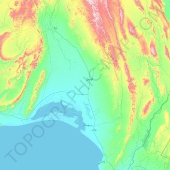
Name: Lasbela District topographic map, elevation, terrain.
Location: Lasbela District, Balochistan, Pakistan (25.05000 65.88333 26.45000 67.28333)
Average elevation: 245 m
Minimum elevation: -2 m
Maximum elevation: 1,378 m
Other topographic maps
Click on a map to view its topography, its elevation and its terrain.
Khuzdar District
Pakistan > Balochistan > Khuzdar District
During the period of Arab rule, this region formed the province of Turan, with Khuzdar as the capital. It was an important cantonment and was the headquarters of the Arab General Commanding the Indian frontier. Later Khuzdar became a part of the Kalat State. It was the scene of a battle between the people of…
Average elevation: 793 m