
Kashiwazaki topographic map
Interactive map
Click on the map to display elevation.
About this map
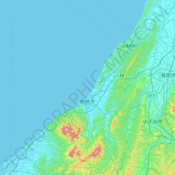
Name: Kashiwazaki topographic map, elevation, terrain.
Location: Kashiwazaki, Niigata Prefecture, Japan (37.15985 138.12889 37.66056 138.72176)
Average elevation: 66 m
Minimum elevation: -1 m
Maximum elevation: 942 m
Kashiwazaki is located in a coastal region of south-central Niigata Prefecture. Part of the city is within the borders of the Sado-Yahiko-Yoneyama Quasi-National Park. The highest elevation is the summit of Mount Gozu at 912 meters.
Other topographic maps
Click on a map to view its topography, its elevation and its terrain.
Mount Fuji
Japan > Sunto County > Oyama
Mount Fuji, Oyama, Sunto County, Shizuoka Prefecture, Chubu Region, Japan
Average elevation: 3,261 m
Lake Sanaru
Lake Sanaru, Hamamatsu, Shizuoka Prefecture, Chubu Region, Japan
Average elevation: 16 m
Motoyama
Motoyama, Nagaoka County, Kochi Prefecture, 781-3601, Japan
Average elevation: 679 m
Setouchi
Setouchi, Oshima County, Kagoshima Prefecture, Japan
Average elevation: 26 m
Higashishirakawa
Higashishirakawa, Kamo County, Gifu Prefecture, Chubu Region, 509-1392, Japan
Average elevation: 658 m
Nishikigaoka-chuo Park
Nishikigaoka-chuo Park, Nishikigaoka 2-chome, Aoba Ward, Sendai, Miyagi Prefecture, Japan
Average elevation: 197 m
Katsura Imperial Villa
Katsura Imperial Villa, Road No. 142, Katsura-Kasugacho, Nishikyo Ward, Kyoto, Kyoto Prefecture, 615-8013, Japan
Average elevation: 25 m