
Chaoyang District topographic map
Interactive map
Click on the map to display elevation.
About this map
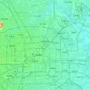
Name: Chaoyang District topographic map, elevation, terrain.
Location: Chaoyang District, Beijing, PRC (39.80834 116.34472 40.10942 116.63927)
Average elevation: 41 m
Minimum elevation: 18 m
Maximum elevation: 210 m
Other topographic maps
Click on a map to view its topography, its elevation and its terrain.
Houhai Lake
PRC > Beijing > Xicheng District
Houhai Lake, Houhaibeiyuan, Shichahai, Xicheng District, Beijing, 100032, PRC
Average elevation: 52 m